Historic photos from around Yorkville, Toronto
The Yorkville coat of arms (brewer, brick maker, anvil, wood-plane, and sheep in the center) reflects the early character of the area. Yorkville was created as a residential suburb of Toronto in 1830 by Joseph Bloor and William Botsford Jarvis. The area grew, and by 1853 the population exceeded 1,000 people, large enough that it could be incorporated as the Village of Yorkville. The Potters Field cemetery, north east of Yonge and Bloor, was closed in 1870, with the remains moved to the Toronto Necropolis and Mount Pleasant cemetery. On Februrary 1st, 1883 the City of Toronto annexed the area, renaming it St. Paul's Ward.List of all areas in Toronto or take a look at the historic photos by date. New! You can now access the photos by street address A subset of the photos have also been arranged by subject.
| 1850 |  | Pencil sketch of the H.B. Williams 'Yorkville Buss Line' coach in front of the Red Lion Hotel - John Ross Robertson Collection 176 years ago - 1850 - Yorkville at 767 Yonge Street just north of Bloor Street Link to archive record - Map location (From the City of Toronto Archives) |
| 1860 |  | Opening of the first rail line north of Bloor - Yonge St. looking n. from n. of Asquith Ave. - Yorkville Town Hall (Categorized under: Yorkville Town Hall ) 166 years ago - 1860 - Yorkville at 773 Yonge Street north of Asquith Ave Link to archive record - Map location (From the Toronto Public Library) |
| 1865 | 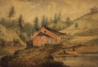 | Joseph Bloor brewery, n. of Bloor St. E., between Mount Pleasant Rd. & Sherbourne St. 161 years ago - 1865 - Yorkville Link to archive record - Map location (From the Toronto Public Library) |
| 1870 | 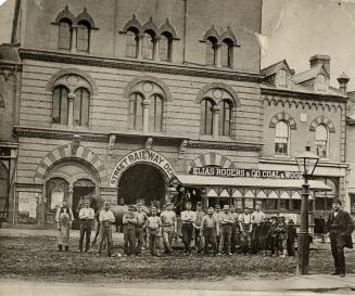 | Horse drawn trolley (with ad for Elias Rogers & Co. coal & wood) outside Yorkville Town Hall with Street Railway Depot sign over the door (Categorized under: Yorkville Town Hall ) 156 years ago - 1870 - Yorkville at 854 Yonge Street west side across from Collier Street Link to archive record - Map location (From the Toronto Public Library) |
| 1875 | 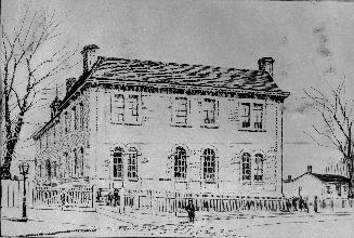 | Jesse Ketchum School c.1875 - Alexander Muir was principal 1871-2 (Categorized under: Schools ) 151 years ago - 1875 - Yorkville Link to archive record - Map location (From the Toronto Public Library) |
| 1885 | 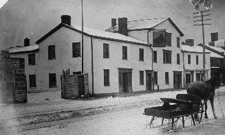 | Red Lion Hotel showing sign out front and horse and sleigh 141 years ago - 1885 - Yorkville at 767 Yonge Street just north of Bloor Street Link to archive record - Map location (From the Toronto Public Library) |
| 1886 | 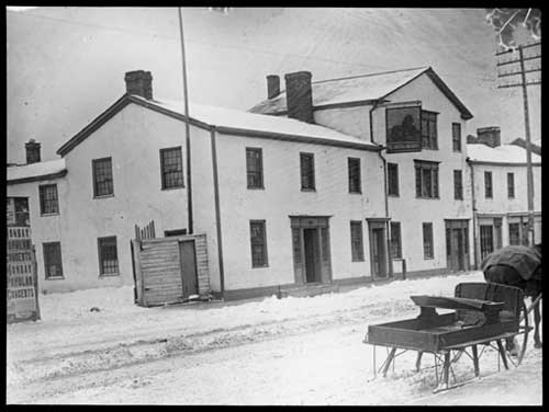 | The Red Lion Inn, opened ca 1810 - where the Albert Britnell's bookstore then stood 140 years ago - 1886 - Yorkville at 767 Yonge Street just north of Bloor Street Link to archive record - Map location (From Archives of Ontario) |
| 1893 | 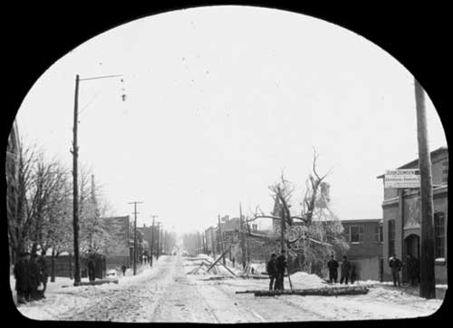 | View of Yonge Street, looking north from Scollard Street, Toronto 133 years ago - 1893 - Yorkville at 819 Yonge Street (approx) at Scollard Street Link to archive record - Map location (From Archives of Ontario) |
| 1900 |  | Yorkville Town Hall interior - council room in use as Toronto Public Library (Categorized under: Yorkville Town Hall ) 126 years ago - 1900 - Yorkville at 854 Yonge Street west side across from Collier Street Link to archive record - Map location (From the Toronto Public Library) |
| 1905 |  | Margaret Eaton School of Literature and Expression 121 years ago - 1905 - Yorkville Link to archive record - Map location (From the City of Toronto Archives) |
| 1906 |  | Yorkville Town Hall tower - painting from Yonge Street, west side, opposite Collier St (Categorized under: Yorkville Town Hall ) 120 years ago - 1906 - Yorkville at 854 Yonge Street across from Collier Street Link to archive record - Map location (From the Toronto Public Library) |
| 1907 | 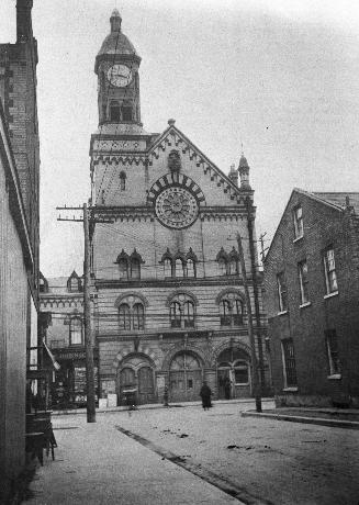 | Yorkville Town Hall, Yonge St., w. side, opposite Collier St. built 1860 by architect William Hay and apprentice Henry Langley 119 years ago - 1907 - Yorkville Link to archive record - Map location (From the Toronto Public Library) |
| 1907 | | Yorkville Town Hall looking west from Collier St (Categorized under: Yorkville Town Hall ) 119 years ago - 1907 - Yorkville at 854 Yonge Street west side across from Collier Street Link to archive record - Map location (From the Toronto Public Library) |
| 1908 |  | Margaret Eaton School of Literature and Expression built 1905 by W.R. Mead at 38 1/2 North St (Categorized under: Schools ) 118 years ago - 1908 - Yorkville Link to archive record - Map location (From the City of Toronto Archives) |
| 1909 | Jesse Ketchum School office and teacher (Categorized under: Schools ) 117 years ago - 1909 - Yorkville at 61 Davenport Road Link to archive record - Map location (From the Library and Archives Canada) |
|
| 1910 | 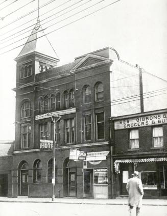 | Lennox Hotel with illuminated sign - Yonge St. e. side, south of present Church St. (Categorized under: Hotels ) 116 years ago - 1910 - Yorkville Link to archive record - Map location (From the Toronto Public Library) |
| 1910 | 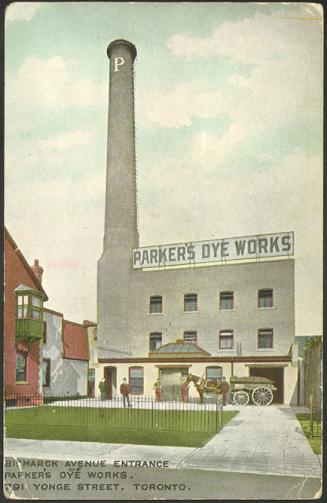 | Bismarck Avenue entrance of Parker's Dye Works - men and horse drawn cart 116 years ago - 1910 - Yorkville at 791 Yonge Street south of Yorkville Ave. Link to archive record - Map location (From the Toronto Public Library) |
| 1912 | Jesse Ketchum School classroom - interior (Categorized under: Schools ) 114 years ago - 1912 - Yorkville at 61 Davenport Road Link to archive record - Map location (From the Library and Archives Canada) |
|
| 1912 | 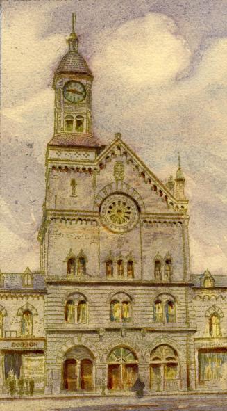 | Painting of St. Paul's Hall (previously the Yorkville Town Hall) (Categorized under: Yorkville Town Hall ) 114 years ago - 1912 - Yorkville at 854 Yonge Street west side across from Collier Street Link to archive record - Map location (From the Toronto Public Library) |
| 1912 |  | Historic map of Bloor and Bay Street for Terauley Street Widening - Charles St. and St. Mary 114 years ago - Monday, September 9, 1912 - Yorkville Max temp: 26.1°C - Min temp: 16.7°C (weather details) Link to archive record - Map location (From the City of Toronto Archives) |
| 1917 | 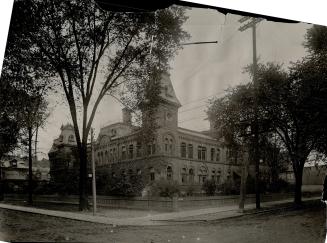 | Wellesley Public School, St. Vincent Street (now Bay Street), and St. Albans Street (now Wellesley Street West) (Categorized under: Schools ) 109 years ago - Monday, November 5, 1917 - Yorkville at 955 Bay Street n.e. corner at Wellesley Street West Link to archive record - Map location (From the Toronto Public Library) |
| 1917 |  | Masonic master lays cornerstone for Masonic Temple in 1917, Yonge Street and Davenport Road 109 years ago - Saturday, November 17, 1917 - Yorkville at 888 Yonge Street n.w. corner at Davenport Link to archive record - Map location (From the City of Toronto Archives) |
| 1920 | | Old residence, south side of Bloor Street West between Bay and Yonge 106 years ago - 1920 - Yorkville Link to archive record - Map location (From the City of Toronto Archives) |
| 1920 |  | Westminster Church fire aftermath - news reel - Bloor East at Park Road (Categorized under: Churches and other places of worship ) 106 years ago - Monday, February 2, 1920 - Yorkville at 117 Bloor Street East at Park Road Link to archive record - Map location |
| 1920 | | Westminster United Church after Jan 30th 1920 fire (Categorized under: Churches and other places of worship ) 106 years ago - Monday, February 2, 1920 - Yorkville at 121 Bloor Street West Link to archive record - Map location (From the City of Toronto Archives) |
| 1920 | Westminster (Presbyterian) Church, fire ruins, 49 Bloor east. Toronto, Ont (Categorized under: Churches and other places of worship ) 106 years ago - Monday, February 2, 1920 - Yorkville at 121 Bloor Street East Link to archive record - Map location (From the Library and Archives Canada) |
|
| 1920 | Westminster Church fire - bystanders looking at frozen Church (Categorized under: Churches and other places of worship ) 106 years ago - Monday, February 2, 1920 - Yorkville at 121 Bloor Street East Link to archive record - Map location (From the Library and Archives Canada) |
|
| 1921 | 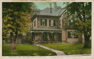 | Lynhurst (sic) Hospital - Torontos Best Equipped Private Hospital at the time - expanded to Mount Sinai Hospital 105 years ago - 1921 - Yorkville at 100 Yorkville Ave Link to archive record - Map location (From the Toronto Public Library) |
| 1921 | | Margaret Eaton School, North Street (now Bay Street) (Categorized under: Schools ) 105 years ago - Friday, March 4, 1921 - Yorkville Max temp: -5.0°C - Min temp: -13.9°C (weather details) Link to archive record - Map location (From the City of Toronto Archives) |
| 1921 | | 52 North Street - Terauley Street Extension 105 years ago - Friday, March 4, 1921 - Yorkville at 52 North Street Max temp: -5.0°C - Min temp: -13.9°C (weather details) Link to archive record - Map location (From the City of Toronto Archives) |
| 1921 | | 51 Yorkville Avenue near Bay - Terauley Street Extension 105 years ago - Friday, April 1, 1921 - Yorkville at 51 Yorkville Ave Max temp: 4.4°C - Min temp: -3.3°C (weather details) Link to archive record - Map location (From the City of Toronto Archives) |
| 1924 | 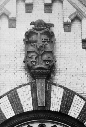 | Yorkville coat or arms - brewer, brick maker, anvil, wood-plane, and sheep in the center (Categorized under: Yorkville Town Hall ) 102 years ago - 1924 - Yorkville Link to archive record - Map location (From the Toronto Public Library) |
| 1924 | 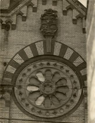 | Yorkville heraldry above the rose window on Yorkville Town Hall - burnt down in 1941 (Categorized under: Yorkville Town Hall ) 102 years ago - 1924 - Yorkville Link to archive record - Map location (From the Toronto Public Library) |
| 1924 | | No. 83-85 Bloor Street West 102 years ago - Tuesday, March 4, 1924 - Yorkville Max temp: 4.4°C - Min temp: 0.6°C (weather details) Link to archive record - Map location (From the City of Toronto Archives) |
| 1925 | 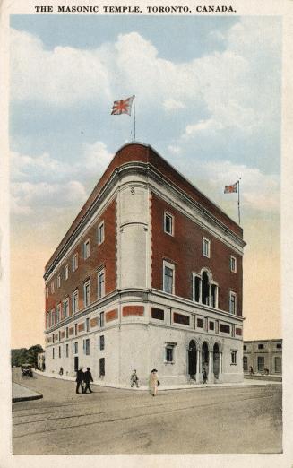 | The Masonic Temple just after opening - Italian Renaissance Revival Style by architect W. J. Sparling (Categorized under: Concert hall ) 101 years ago - 1925 - Yorkville at 888 Yonge Street n.w. corner at Davenport Link to archive record - Map location (From the Toronto Public Library) |
| 1927 | | No. 5 steamer in Centennial Parade, Bloor Street West at Bellair Street 99 years ago - Friday, July 1, 1927 - Yorkville Max temp: 30.6°C - Min temp: 20.0°C (weather details) Link to archive record - Map location (From the City of Toronto Archives) |
| 1927 | | No. 3 hose and chemical wagon in Centennial Parade, Bloor Street West seen from Bellair Street 99 years ago - Friday, July 1, 1927 - Yorkville Max temp: 30.6°C - Min temp: 20.0°C (weather details) Link to archive record - Map location (From the City of Toronto Archives) |
| 1927 | | No. 8 hose wagon in Centennial Parade, Bloor Street West seen from Bellair Street 99 years ago - Friday, July 1, 1927 - Yorkville Max temp: 30.6°C - Min temp: 20.0°C (weather details) Link to archive record - Map location (From the City of Toronto Archives) |
| 1929 | | Bloor Street West, south side, looking east from Avenue Road 97 years ago - 1929 - Yorkville Link to archive record - Map location (From the City of Toronto Archives) |
| 1930 | | Mosher's on Bay Street south of Bloor 96 years ago - 1930 - Yorkville Link to archive record - Map location (From the City of Toronto Archives) |
| 1930 | | Lennox Hotel - 831 Yonge Street at Church - Central Shoe repair and Gibbons & Co Grocers (Categorized under: Hotels ) 96 years ago - Thursday, September 18, 1930 - Yorkville at 831 Yonge Street Max temp: 21.7°C - Min temp: 12.2°C (weather details) Link to archive record - Map location (From the City of Toronto Archives) |
| 1932 | 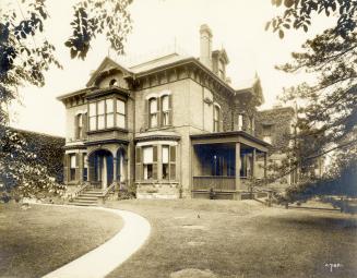 | Sir William Mulock house at 71 Avenue Road Between Yorkville and Webster Ave. 94 years ago - 1932 - Yorkville Link to archive record - Map location (From the Toronto Public Library) |
| 1933 |  | Yorkville Town Hall painted in 1933 by Nicholas Hornyansky (1896-1965) (Categorized under: Yorkville Town Hall ) 93 years ago - 1933 - Yorkville at 854 Yonge Street west side across from Collier Street Link to archive record - Map location (From the Toronto Public Library) |
| 1935 | 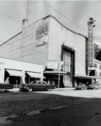 | University Theatre on Bloor Street - ad for Mutiny on the Bounty (1935 film) (Categorized under: Downtown theatres ) 91 years ago - 1935 - Yorkville at 100 Bloor Street West Link to archive record - Map location (From the Toronto Public Library) |
| 1938 | | Snow and Duckworths Furs on Avenue Road looking north from Yorkville Avenue 88 years ago - Thursday, January 13, 1938 - Yorkville Max temp: 0.0°C - Min temp: -5.0°C (weather details) Link to archive record - Map location (From the City of Toronto Archives) |
| 1941 | | St. Paul's Hall after November 1941 fire (Categorized under: Yorkville Town Hall ) 85 years ago - Wednesday, November 26, 1941 - Yorkville at 773 Yonge Street north of Asquith Ave Link to archive record - Map location (From the City of Toronto Archives) |
| 1941 | | Back of St. Pauls Hall after November 1941fire (Categorized under: Yorkville Town Hall ) 85 years ago - Wednesday, November 26, 1941 - Yorkville at 854 Yonge Street west side across from Collier Street Link to archive record - Map location (From the City of Toronto Archives) |
| 1945 | | Babloor Hotel - 1163-1167 Bay St., east side, between Charles St. W. and Bloor St. W. (Categorized under: Hotels ) 81 years ago - 1945 - Yorkville at 1163 Bay Street Link to archive record - Map location (From the City of Toronto Archives) |
| 1948 | 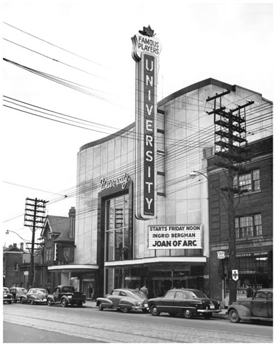 | University Theatre marquee and sign for Joan of Arc with Ingrid Bergman (Categorized under: Downtown theatres ) 78 years ago - Friday, November 5, 1948 - Yorkville Max temp: 18.3°C - Min temp: 10.6°C (weather details) Link to archive record - Map location (From Archives of Ontario) |
| 1948 | 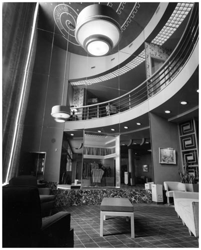 | University Theatre on Bloor Street - sitting area and balcony (Categorized under: Downtown theatres ) 78 years ago - Friday, November 5, 1948 - Yorkville Max temp: 18.3°C - Min temp: 10.6°C (weather details) Link to archive record - Map location (From Archives of Ontario) |
| 1948 | 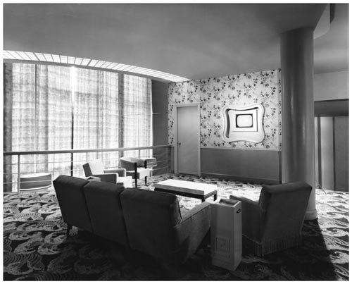 | University Theatre - seating area with window still open to street (Categorized under: Downtown theatres ) 78 years ago - Friday, November 5, 1948 - Yorkville Max temp: 18.3°C - Min temp: 10.6°C (weather details) Link to archive record - Map location (From Archives of Ontario) |
| 1948 | 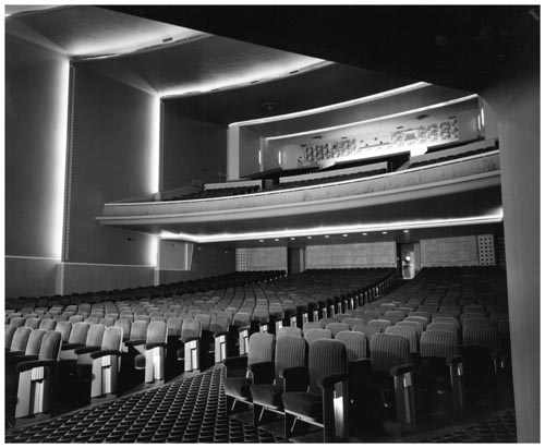 | University Theatre - auditorium and balcony (Categorized under: Downtown theatres ) 78 years ago - Friday, November 5, 1948 - Yorkville Max temp: 18.3°C - Min temp: 10.6°C (weather details) Link to archive record - Map location (From Archives of Ontario) |
| 1952 | 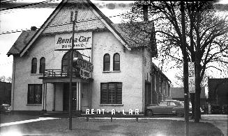 | Yorkville Baptist Church - became Salvation Army barracks (later receiving home) ca 1887-ca 1947; Rent-A-Car Building from ca 1947 74 years ago - 1952 - Yorkville at 916 Yonge Street north of Davenport Road Link to archive record - Map location (From the Toronto Public Library) |
| 1954 | 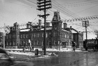 | Wellesley Public School at Bay and Wellesley - run as a school from 1874 to 1956 (Categorized under: Schools ) 72 years ago - Monday, February 15, 1954 - Yorkville at 955 Bay Street n.e. corner at Wellesley Street West Link to archive record - Map location (From the Toronto Public Library) |
| 1959 | | The Concert Hall and gas station at Yonge and Church and Davenport (Categorized under: Concert hall ) 67 years ago - 1959 - Yorkville at 888 Yonge Street looking east along Church to Yonge St Link to archive record - Map location (From the City of Toronto Archives) |
| 1959 |  | Canadian Tire gas bar with butterfly canopy - Yonge Street and Church Street 67 years ago - Friday, November 20, 1959 - Yorkville Max temp: 3.9°C - Min temp: -2.2°C (weather details) Link to archive record - Map location (From the City of Toronto Archives) |
| 1960 | 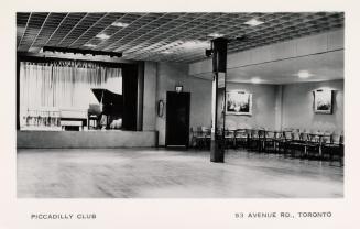 | Piccadilly Club - interior with piano, stage, and dancefloor - 53 Avenue Road 66 years ago - 1960 - Yorkville at 53 Avenue Road at Lowther Ave Link to archive record - Map location (From the Toronto Public Library) |
| 1963 | 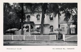 | Piccadilly Club exterior with white picket fence - 53 Avenue Road in Yorkville 63 years ago - 1963 - Yorkville at 53 Avenue Road east side at Lowther Ave Link to archive record - Map location (From the Toronto Public Library) |
| 1965 |  | Riverboat entrance downstairs in Yorkville in 1965 - Gord Lightfoot coming next (Categorized under: Live music ) 61 years ago - Saturday, May 29, 1965 - Yorkville at 134 Yorkville Ave east of Avenue Road Link to archive record - Map location (From York University Archives) |
| 1965 |  | Riverboat coffee house - Harry Belafonte in front of distinctive porthole window (Categorized under: Live music ) 61 years ago - Wednesday, June 2, 1965 - Yorkville at 134 Yorkville Ave east of Avenue Road Link to archive record - Map location (From York University Archives) |
| 1965 |  | Riverboat coffee house - The Dirty Shames in performance in Yorkville - Carol Robinson singing with washboard (Categorized under: Live music ) 61 years ago - Tuesday, December 21, 1965 - Yorkville at 134 Yorkville Ave just east of Avenue Road Link to archive record - Map location (From York University Archives) |
| 1966 | Yorkville in the 1960s - looking north on Avenue Road to Elgin Ave 60 years ago - Saturday, November 5, 1966 - Yorkville at 66 Avenue Road Link to archive record - Map location (From the Library and Archives Canada) |
|
| 1966 | St. Paul's Avenue Road church - playing guitar looking south to Yorkville 60 years ago - Saturday, November 5, 1966 - Yorkville at 121 Avenue Road Link to archive record - Map location (From the Library and Archives Canada) |
|
| 1967 | 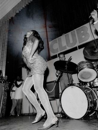 | Tina Turner live on stage in Toronto at Club 888 in 1967 (Categorized under: Concert hall ) 59 years ago - Wednesday, September 27, 1967 - Yorkville at 888 Yonge Street n.w. corner at Davenport Road Link to archive record - Map location (From the Toronto Public Library) |
| 1967 | 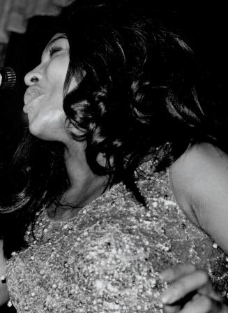 | Tina Turner singing live on stage in Toronto at Club 888 (the Concert Hall) in 1967 (Categorized under: Concert hall ) 59 years ago - Wednesday, September 27, 1967 - Yorkville at 888 Yonge Street Link to archive record - Map location (From the Toronto Public Library) |
| 1967 |  | Mynah Bird coffeehouse - topless Wyche and The Remnants - her guitar was considered clothing (Categorized under: Live music ) 59 years ago - Monday, December 18, 1967 - Yorkville at 114 Yorkville Ave n.e. corner at Hazelton Ave. Link to archive record - Map location (From York University Archives) |
| 1969 | 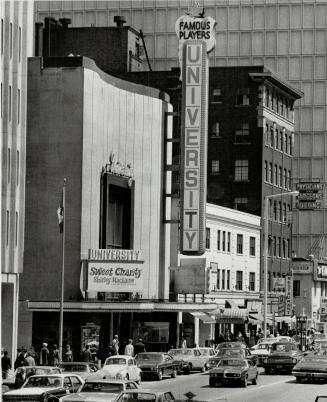 | University Theatre (1949-1986) on Bloor Street West, north side, between Bellair Street and Avenue Road, Toronto, Ontario (Categorized under: Downtown theatres ) 57 years ago - Thursday, May 1, 1969 - Yorkville at 100 Bloor Street West Link to archive record - Map location (From the Toronto Public Library) |
| 1969 |  | The Who live in Toronto at the Rockpile in 1969 (9 audio tracks) (Categorized under: Concert hall ) 57 years ago - Monday, May 19, 1969 - Yorkville at 888 Yonge Street Link to archive record - Map location |
| 1969 |  | Frank Zappa & The Mothers Of Invention live in Toronto at the Rockpile in 1969 (17 audio tracks) (Categorized under: Concert hall ) 57 years ago - Saturday, May 24, 1969 - Yorkville at 888 Yonge Street Link to archive record - Map location |
| 1969 | 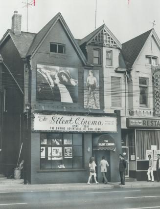 | Silent Cinema - 46-seat theatre devoted exclusively to silent movies - 1926 Don Juan was played on opening night (Categorized under: Midtown theatres ) 57 years ago - Monday, September 15, 1969 - Yorkville at 133 Avenue Road just south of Davenport Road Link to archive record - Map location (From the Toronto Public Library) |
| 1970 | | Sutton Place hotel - driveway and entrance - Bay and Wellesley - opened 1967 (Categorized under: Hotels ) 56 years ago - Wednesday, July 1, 1970 - Yorkville Max temp: 26.1°C - Min temp: 17.2°C (weather details) Link to archive record - Map location (From the City of Toronto Archives) |
| 1971 |  | Mynah Bird coffeehouse in Yorkville - daytime picket (Categorized under: Live music ) 55 years ago - Friday, March 26, 1971 - Yorkville at 114 Yorkville Ave n.w. corner at Hazelton Ave. Link to archive record - Map location (From York University Archives) |
| 1971 | | Tranquility Bay store window - 690 Yonge Street, south of St. Mary 55 years ago - Tuesday, July 27, 1971 - Yorkville at 690 Yonge Street Max temp: 22.2°C - Min temp: 12.8°C (weather details) Link to archive record - Map location (From the City of Toronto Archives) |
| 1976 | | Yorkville streetlife - Rolls-Royce Corniche convertible in front of L'Aiglon french restaurant and Tavern at 121 Yorkville Avenue 50 years ago - 1976 - Yorkville at 121 Yorkville Ave south end of Hazelton Ave Link to archive record - Map location (From the City of Toronto Archives) |
| 1978 | 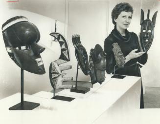 | A display of African face masks at the Marianne Friedland Gallery at 122 Scollard St in 1978 48 years ago - Thursday, February 9, 1978 - Yorkville at 122 Scollard Street just west of Hazelton Ave Link to archive record - Map location (From the Toronto Public Library) |
| 1981 | 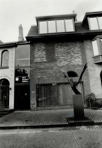 | Mira Godard Gallery on Hazelton Ave in Yorkville 45 years ago - Tuesday, May 26, 1981 - Yorkville at 22 Hazelton Ave at Scollard Street Link to archive record - Map location (From the Toronto Public Library) |
| 1981 |  | Iron Maiden live on at Toronto's Concert Hall on June 21, 1981 (Categorized under: Concert hall ) 45 years ago - Sunday, June 21, 1981 - Yorkville at 888 Yonge Street n.w. corner at Davenport Link to archive record - Map location |
| 1981 | 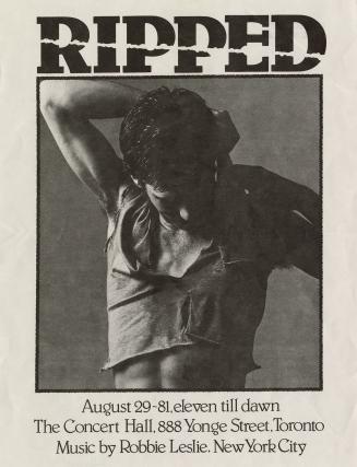 | Robbie Leslie poster - Ripped - eleven till dawn at the Concert Hall (Categorized under: Concert hall ) 45 years ago - Saturday, August 29, 1981 - Yorkville at 888 Yonge Street n.w. corner at Davenport Road Link to archive record - Map location (From the Toronto Public Library) |
| 1982 |  | The Spoons live on stage the Concert Hall in Toronto on October 29th, 1982 (Categorized under: Concert hall ) 44 years ago - Friday, October 29, 1982 - Yorkville at 888 Yonge Street n.w. corner at Davenport Link to archive record - Map location |
| 1983 | | University Theatre on Bloor St. showing Return of the Jedi (opened 1949, closed 1986) (Categorized under: Downtown theatres ) 43 years ago - 1983 - Yorkville Link to archive record - Map location (From the City of Toronto Archives) |
| 1984 | | Streets of Toronto - The Shuffle Demons busking at Yonge and Bloor - Stich Wynston, Mike Murley, Dave Parker and Richard Underhill (Categorized under: Live music ) 42 years ago - 1984 - Yorkville at 741 Yonge Street n.e. corner at Bloor Street Link to archive record - Map location (From the City of Toronto Archives) |
| 1985 |  | R.E.M live on stage at the Concert Hall in Toronto in 1985 (28 live audio tracks) (Categorized under: Concert hall --- Live music ) 41 years ago - Friday, August 16, 1985 - Yorkville at 888 Yonge Street n.w. corner at Davenport Road Link to archive record - Map location |
| 1988 |  | George Bowling house - 113 Hazelton Ave - built in 1880 38 years ago - Saturday, January 2, 1988 - Yorkville Max temp: -3.9°C - Min temp: -8.5°C (weather details) Link to archive record - Map location (From Collations Flickr stream) |
| 1990 | 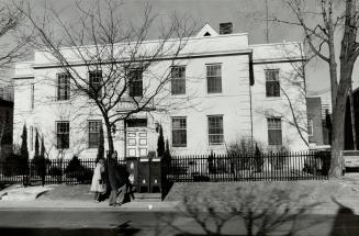 | Toronto Hebrew Maternity and Convalescent Hospital (1923) renamed Mount Sinai Hospital in 1924 - can still see the roof and chimney of original 1871 house 36 years ago - Friday, February 2, 1990 - Yorkville at 100 Yorkville Ave Link to archive record - Map location (From the Toronto Public Library) |
| 1990 |  | Iggy Pop live in Toronto at the Concert Hall in 1990 - Brick By Brick Tour (1.5 hour audio) (Categorized under: Concert hall ) 36 years ago - Monday, November 12, 1990 - Yorkville at 888 Yonge Street n.w. corner at Davenport Road Link to archive record - Map location |
| 1990 |  | Jane's Addiction live in Toronto in 1990 at the Concert Hall (1+ hour audio track) (Categorized under: Concert hall ) 36 years ago - Sunday, November 25, 1990 - Yorkville at 888 Yonge Street n.w. corner at Davenport Road Link to archive record - Map location |
| 1991 | 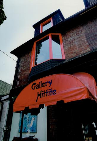 | Gallery Hittite - a Scollard St. art gallery, like many in Yorkville, in a converted house 35 years ago - Monday, September 2, 1991 - Yorkville at 107 Scollard Street east of Hazelton Ave Link to archive record - Map location (From the Toronto Public Library) |
| 1992 |  | Pearl Jam live in Toronto in 1992 at the Concert Hall (15 live audio tracks) (Categorized under: Concert hall ) 34 years ago - Saturday, April 4, 1992 - Yorkville at 888 Yonge Street n.w. corner at Davenport Road Link to archive record - Map location |
| 1992 | 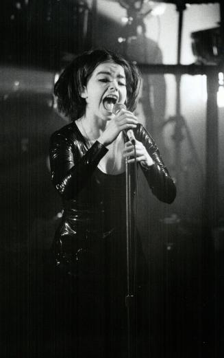 | Bjork of The Sugarcubes live on stage in 1992 at the Concert Hall (Categorized under: Concert hall ) 34 years ago - Monday, April 13, 1992 - Yorkville at 888 Yonge Street Link to archive record - Map location (From the Toronto Public Library) |
| 1992 |  | Sonic Youth live at the Concert Hall in Toronto in 1992 (17 live audio tracks) (Categorized under: Concert hall ) 34 years ago - Thursday, October 15, 1992 - Yorkville at 888 Yonge Street n.w. corner at Davenport Road Link to archive record - Map location |
| 1993 |  | Ned's Atomic Dustbin live at Toronto's Concert Hall in 1993 (1 hour audio) (Categorized under: Concert hall ) 33 years ago - Monday, January 25, 1993 - Yorkville at 888 Yonge Street n.w. corner at Davenport Road Link to archive record - Map location |
| 1993 |  | The Pursuit of Happiness (TPOH) live in Toronto at the Concert Hall in 1993 including a medley of covers (1+ hour audio track) (Categorized under: Concert hall ) 33 years ago - Friday, April 16, 1993 - Yorkville at 888 Yonge Street n.w. corner at Davenport Road Link to archive record - Map location |
| 1993 |  | Green Day live on stage at the Concert Hall in Toronto on October 6th, 1993 (Categorized under: Concert hall ) 33 years ago - Wednesday, October 6, 1993 - Yorkville at 888 Yonge Street n.w. corner at Davenport Link to archive record - Map location |
| 1994 | | Windsor Arms Hotel - south of Bloor in Yorkville, Toronto at 18 St. Thomas - built 1927 (Categorized under: Hotels --- King Edward Hotel ) 32 years ago - 1994 - Yorkville at 18 St. Thomas Street south of Bloor Street Link to archive record - Map location (From the City of Toronto Archives) |
| 1994 | 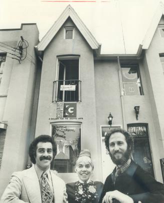 | Three-storey townhouse at 83 Scollard St. in Yorkville - new occupants in 1994 32 years ago - Tuesday, October 25, 1994 - Yorkville at 83 Scollard Street west of Bay Street Link to archive record - Map location (From the Toronto Public Library) |
| 2004 | | Windsor Arms Hotel with 1990's condo tower addition (Categorized under: Hotels ) 22 years ago - Wednesday, September 1, 2004 - Yorkville at 18 St. Thomas Street south of Bloor Street Link to archive record - Map location (From the City of Toronto Archives) |
| 2015 | | Moses Staunton Buildings - 840 Yonge Street - boarded up before condo and redevelopment 11 years ago - Friday, December 11, 2015 - Yorkville at 840 Yonge Street west side between Yorkville Ave and Cumberland Street Link to archive record - Map location (From the City of Toronto Archives) |