Historic photos from around Summerhill, Toronto
The name Summerhill is an excellent reminder of how the City of Toronto grew - in the mid-1800's rich Torontonian's built summer homes along the ancient Iroquois Shoreline running east west, parallel to Davenport Road. The Summerhill neighbourhood is named after the 'Summer House' built by Charles Thompson (designed by architect John Howard) in 1842 on the 200 acre lot running east from Yonge Street to the ravine. The area was eventually turned into the "Summer Hill Spring Park and Pleasure Grounds" with rides, games, a swimming pool, and a popular dancehall in the original house. All that remains today is Summerhill Avenue which was the original entrance to the property, and the Summer Hill Coach House (from 1865).List of all areas in Toronto or take a look at the historic photos by date. New! You can now access the photos by street address A subset of the photos have also been arranged by subject. Tweet
| 1870 | 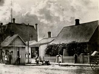 | Last Toll Gate on Yonge St., n. of Marlborough Ave. (Categorized under: Ornamental gate ) 154 years ago - 1870 - Summerhill Link to archive record - Map location (From the Toronto Public Library Still not back as of March 2024) |
| 1876 | 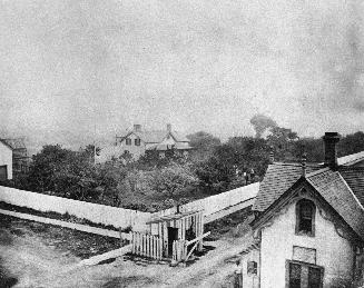 | Toll house at the corner of Davenport and Avenue Road - looking n.e. to Leonard Pears house (Categorized under: Ornamental gate ) 148 years ago - 1876 - Summerhill Link to archive record - Map location (From the Toronto Public Library Still not back as of March 2024) |
| 1899 | 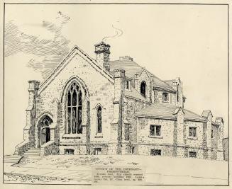 | Sketch of the Church of the Covenant before west section added - Avenue Road and Roxborough (Categorized under: Architectural drawings --- Avenue road church (at roxborough) ) 125 years ago - 1899 - Summerhill Link to archive record - Map location (From the Toronto Public Library Still not back as of March 2024) |
| 1900 | 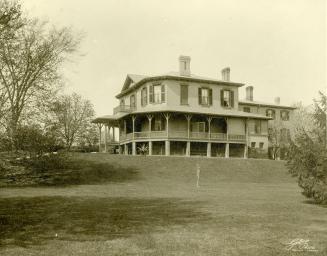 | William Laratt Smith's Summerhill - Summerhill Ave., n. side, w. of David A. Balfour Park 124 years ago - 1900 - Summerhill Link to archive record - Map location (From the Toronto Public Library Still not back as of March 2024) |
| 1906 |  | Interior of the Cottingham Street Mens lavatory at Yonge Street 118 years ago - Thursday, February 22, 1906 - Summerhill Max temp: 0.6°C - Min temp: -2.8°C (weather details) Link to archive record - Map location (From the City of Toronto Archives) |
| 1906 |  | Interior of the Cottingham Street Mens washroom at Yonge Street 118 years ago - Thursday, February 22, 1906 - Summerhill Max temp: 0.6°C - Min temp: -2.8°C (weather details) Link to archive record - Map location (From the City of Toronto Archives) |
| 1906 |  | Exterior of the Cottingham Street Mens washroom at Yonge Street 118 years ago - Thursday, February 22, 1906 - Summerhill Max temp: 0.6°C - Min temp: -2.8°C (weather details) Link to archive record - Map location (From the City of Toronto Archives) |
| 1910 |  | Avenue Road, looking south to Dupont Street w/ Avenue Rd. Presbyterian church on the left (Categorized under: Avenue road church (at roxborough) ) 114 years ago - 1910 - Summerhill Link to archive record - Map location (From the City of Toronto Archives) |
| 1913 |  | Yonge Street - Summerhill Avenue crossing 111 years ago - Tuesday, May 13, 1913 - Summerhill Max temp: 16.1°C - Min temp: 6.1°C (weather details) Link to archive record - Map location (From the City of Toronto Archives) |
| 1913 |  | Yonge Street - Summerhill Avenue crossing looking south 111 years ago - Thursday, June 19, 1913 - Summerhill Max temp: 18.3°C - Min temp: 10.6°C (weather details) Link to archive record - Map location (From the City of Toronto Archives) |
| 1915 |  | Summerhill Avenue bridge 109 years ago - Wednesday, April 21, 1915 - Summerhill Max temp: 10.6°C - Min temp: 1.1°C (weather details) Link to archive record - Map location (From the City of Toronto Archives) |
| 1921 |  | Living room and furnishings of Woodlawn, north and west view 103 years ago - 1921 - Summerhill Link to archive record - Map location (From the City of Toronto Archives) |
| 1921 |  | Dining room and art at Woodlawn, south and east view 103 years ago - 1921 - Summerhill Link to archive record - Map location (From the City of Toronto Archives) |
| 1921 |  | Living room and grand windows at Woodlawn, east and north view 103 years ago - 1921 - Summerhill Link to archive record - Map location (From the City of Toronto Archives) |
| 1921 |  | Not so grand view looking east of the west elevation of Woodlawn during renovation? 103 years ago - 1921 - Summerhill Link to archive record - Map location (From the City of Toronto Archives) |
| 1921 |  | Garden and path, looking east on the south side of Woodlawn 103 years ago - 1921 - Summerhill Link to archive record - Map location (From the City of Toronto Archives) |
| 1921 |  | Exterior view of gardens looking west from Woodlawn, on the south side 103 years ago - 1921 - Summerhill Link to archive record - Map location (From the City of Toronto Archives) |
| 1924 |  | Southwest corner Yonge and Roxborough - Gas Station 100 years ago - Wednesday, February 27, 1924 - Summerhill Max temp: 3.9°C - Min temp: -12.2°C (weather details) Link to archive record - Map location (From the City of Toronto Archives) |
| 1949 | 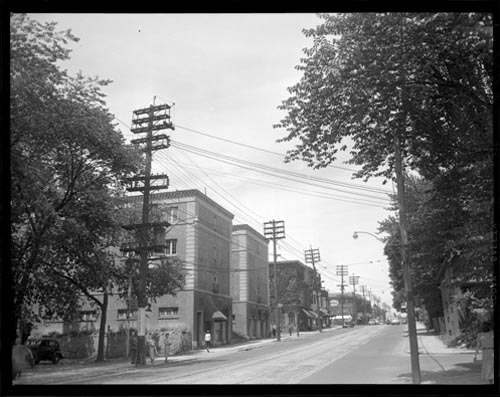 | Yonge Street and Roxborough Street East looking north 75 years ago - Monday, August 22, 1949 - Summerhill at 1110 Yonge Street Max temp: 28.3°C - Min temp: 18.9°C (weather details) Link to archive record - Map location (From Archives of Ontario) |
| 1949 | 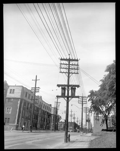 | Yonge and Roxborough looking south 75 years ago - Monday, August 22, 1949 - Summerhill at 110 Yonge Street Max temp: 28.3°C - Min temp: 18.9°C (weather details) Link to archive record - Map location (From Archives of Ontario) |
| 1956 | 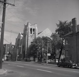 | Avenue Rd. Presbyterian (United) Church before building torn down for Jay Macpherson Green (Categorized under: Avenue road church (at roxborough) ) 68 years ago - Sunday, August 26, 1956 - Summerhill Max temp: 25.6°C - Min temp: 12.2°C (weather details) Link to archive record - Map location (From the Toronto Public Library Still not back as of March 2024) |
| 1959 |  | Before Avenue Road widening outside the The Avenue Rd. Church (Categorized under: Avenue road church (at roxborough) ) 65 years ago - Thursday, April 16, 1959 - Summerhill Max temp: 24.4°C - Min temp: 8.9°C (weather details) Link to archive record - Map location (From the City of Toronto Archives) |
| 1960 |  | Looking south down Avenue Road to The Avenue Road Church on the left (Categorized under: Avenue road church (at roxborough) ) 64 years ago - Wednesday, June 22, 1960 - Summerhill Max temp: 21.7°C - Min temp: 15.0°C (weather details) Link to archive record - Map location (From the City of Toronto Archives) |
| 1977 | Summerhill TTC subway station: close-up of the name of the station on the wall, behind a row of red seats 47 years ago - 1977 - Summerhill at 24 Shaftesbury Ave Link to archive record - Map location (From the Library and Archives Canada) |
|
| 2014 |  | Hare Krishna leaded glass window 1 (Categorized under: Avenue road church (at roxborough) ) 10 years ago - Saturday, May 24, 2014 - Summerhill Max temp: 0.0°C - Min temp: 0.0°C (weather details) Link to archive record - Map location |
| 2014 |  | Hare Krishna Peacocks (Categorized under: Avenue road church (at roxborough) ) 10 years ago - Saturday, May 24, 2014 - Summerhill Max temp: 0.0°C - Min temp: 0.0°C (weather details) Link to archive record - Map location |
| 2014 |  | Hare Krishna Column (Categorized under: Avenue road church (at roxborough) ) 10 years ago - Saturday, May 24, 2014 - Summerhill Max temp: 0.0°C - Min temp: 0.0°C (weather details) Link to archive record - Map location |