Historic photos from around Davenport, Toronto
There are a wonderful set of Toronto historic photos available online, here are all the photos that I could find from around the Davenport area in Toronto, Ontario, Canada.List of all areas in Toronto or take a look at the historic photos by date. New! You can now access the photos by street address A subset of the photos have also been arranged by subject. Tweet
| 1913 | 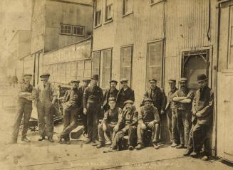 | Mechanics at Hepburns Foundry on Dupont 111 years ago - 1913 - Davenport at 928 Dupont Street (approx.) between Ossington Ave. & Dovercourt Road Link to archive record - Map location (From the Toronto Public Library Still not back as of March 2024) |
| 1914 |  | Trees cut down on Christie Street south to Davenport Road 110 years ago - Friday, January 23, 1914 - Davenport Max temp: 5.6°C - Min temp: -6.7°C (weather details) Link to archive record - Map location (From the City of Toronto Archives) |
| 1914 |  | Trees being cut on Christie Street north from Davenport Road 110 years ago - Friday, January 23, 1914 - Davenport Max temp: 5.6°C - Min temp: -6.7°C (weather details) Link to archive record - Map location (From the City of Toronto Archives) |
| 1914 |  | Trees and houses - southeast corner of Christie Street and Braemore Gardens 110 years ago - Tuesday, January 27, 1914 - Davenport Max temp: 6.7°C - Min temp: 0.0°C (weather details) Link to archive record - Map location (From the City of Toronto Archives) |
| 1914 |  | Removing the hill with horse and carts - Christie Street north from Davenport Road 110 years ago - Wednesday, February 18, 1914 - Davenport Max temp: -3.9°C - Min temp: -13.9°C (weather details) Link to archive record - Map location (From the City of Toronto Archives) |
| 1914 |  | Horse and women with umbrellas at Christie St. north over Davenport Road 110 years ago - Thursday, July 9, 1914 - Davenport Max temp: 28.3°C - Min temp: 19.4°C (weather details) Link to archive record - Map location (From the City of Toronto Archives) |
| 1915 |  | Christie Street north from Davenport Road 109 years ago - Friday, August 6, 1915 - Davenport Max temp: 22.8°C - Min temp: 15.6°C (weather details) Link to archive record - Map location (From the City of Toronto Archives) |
| 1919 |  | Homestead on Christie Street, looking north toward Davenport Road 105 years ago - 1919 - Davenport Link to archive record - Map location (From the City of Toronto Archives) |
| 1921 |  | Homestead south of Davenport at 236 Christie Street 103 years ago - 1921 - Davenport Link to archive record - Map location (From the City of Toronto Archives) |
| 1921 |  | Proposed playground site at Davenport Road, Christie Street, and Benson Avenue 103 years ago - 1921 - Davenport Link to archive record - Map location (From the City of Toronto Archives) |
| 1923 |  | Guests and nurses at the Christie St. Hospital Christmas dinner 101 years ago - Thursday, December 20, 1923 - Davenport Max temp: 8.3°C - Min temp: 5.0°C (weather details) Link to archive record - Map location (From the City of Toronto Archives) |
| 1924 |  | Davenport Rd, looking east, from Christie St with water tower 100 years ago - Tuesday, June 10, 1924 - Davenport Max temp: 23.3°C - Min temp: 8.3°C (weather details) Link to archive record - Map location (From the City of Toronto Archives) |
| 1937 |  | Bracondale - Demolition of Charles E. Turner Estate in Hillcrest Park (Categorized under: Estates and Houses ) 87 years ago - Tuesday, April 20, 1937 - Davenport Max temp: 11.7°C - Min temp: 2.2°C (weather details) Link to archive record - Map location (From the City of Toronto Archives) |
| 1937 |  | Bracondale Hill (1847 - 1937) - Charles Turner house - now Hillcrest Park (Categorized under: Estates and Houses ) 87 years ago - Tuesday, April 20, 1937 - Davenport Max temp: 11.7°C - Min temp: 2.2°C (weather details) Link to archive record - Map location (From the City of Toronto Archives) |