Historic photos from around Harbourfront, TorontoThere are a wonderful set of Toronto historic photos available online, here are all the photos that I could find from around the Harbourfront area in Toronto, Ontario, Canada.List of all areas in Toronto or take a look at the historic photos by date. New! You can now access the photos by street address A subset of the photos have also been arranged by subject. Tweet |
| 1896 | 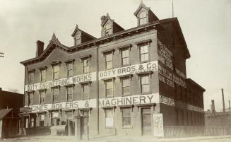 | St. James Hotel, York St., e. side, betw. Esplanade W. & Front St. W. then Doty Engineering Works (Categorized under: Hotels ) 128 years ago - 1896 - Harbourfront Link to archive record - Map location (From the Toronto Public Library Still not back as of March 2024) |
| 1900 |  | Royal Canadian Yacht Club (RCYC) clubhouse, foot of Simcoe Street 124 years ago - 1900 - Harbourfront at 5 Lower Simcoe Street (Approximately) Link to archive record - Map location (From the City of Toronto Archives) |
| 1900 |  | Canadian Pacific Railway freight shed - foot of John Street - Pressed Metal Co 1900 catalogue 124 years ago - 1900 - Harbourfront at 270 Queens Quay West (approximately) Link to archive record - Map location |
| 1900 |  | Polson Iron Works interior - private office (foot of Sherbourne Street) - Pressed Metal Co 1900 catalogue 124 years ago - 1900 - Harbourfront at 254 Lower Sherbourne Street (approximately) Link to archive record - Map location |
| 1904 |  | Queen City Yacht Club and RCYC - Toronto waterfront across the ice from the bay 120 years ago - Wednesday, March 2, 1904 - Harbourfront Max temp: 5.6°C - Min temp: -2.8°C (weather details) Link to archive record - Map location (From the City of Toronto Archives) |
| 1917 |  | Captured German UC97 WWI U-Boat and Toronto Harbour Commission building at the water 107 years ago - 1917 - Harbourfront at 60 Harbour Street n.w. corner at Bay Street Link to archive record - Map location (From the City of Toronto Archives) |
| 1917 |  | Captured WWI German submarine U-boat UC97 107 years ago - 1917 - Harbourfront at 60 Harbour Street n.w. corner at Bay Street Link to archive record - Map location (From the City of Toronto Archives) |
| 1919 | Toronto harbor condition in front of The Toronto Harbour Commission Building (THC) before infill 105 years ago - Monday, February 24, 1919 - Harbourfront at 60 Harbour Street n.w. corner at Bay Street Link to archive record - Map location (From the Library and Archives Canada) |
|
| 1920 |  | Iceboats in front of the Toronto Harbour Commission building 104 years ago - 1920 - Harbourfront at 60 Harbour Street n.w. corner at Bay Street Link to archive record - Map location (From the City of Toronto Archives) |
| 1927 |  | Christie Street patients, conveyed to Lakeside Hospital, by S.S. John Hanlan 97 years ago - Monday, June 6, 1927 - Harbourfront at 9 Queens Quay West Max temp: 19.4°C - Min temp: 5.6°C (weather details) Link to archive record - Map location (From the City of Toronto Archives) |
| 1928 |  | Patients taking the ferry to Lakeside home on Toronto Island on S.S. John Hanlan 96 years ago - Tuesday, May 22, 1928 - Harbourfront at 9 Queens Quay West Max temp: 25.0°C - Min temp: 11.1°C (weather details) Link to archive record - Map location (From the City of Toronto Archives) |
| 1928 |  | Removal of patients, from hospital for Sick Children, to Lakeside Home, via S.S. John Hanlan 96 years ago - Tuesday, May 22, 1928 - Harbourfront at 9 Queens Quay West Max temp: 25.0°C - Min temp: 11.1°C (weather details) Link to archive record - Map location (From the City of Toronto Archives) |
| 1929 |  | Aerial view of Toronto from south of Toronto Harbour Commission building 95 years ago - Tuesday, September 10, 1929 - Harbourfront at 60 Harbour Street n.w. corner at Bay Street Max temp: 24.4°C - Min temp: 16.1°C (weather details) Link to archive record - Map location (From the City of Toronto Archives) |
| 1930 |  | Aerial view of York Street and Queens Quay 94 years ago - 1930 - Harbourfront Link to archive record - Map location (From the City of Toronto Archives) |
| 1930 |  | View of Toronto northwest from Toronto Harbour Commission 94 years ago - Thursday, September 4, 1930 - Harbourfront at 60 Harbour Street n.w. corner at Bay Street Max temp: 22.2°C - Min temp: 11.1°C (weather details) Link to archive record - Map location (From the City of Toronto Archives) |
| 1930 |  | Aerial view of Toronto northeast from Toronto Harbour Commission building 94 years ago - Thursday, September 4, 1930 - Harbourfront at 60 Harbour Street Max temp: 22.2°C - Min temp: 11.1°C (weather details) Link to archive record - Map location (From the City of Toronto Archives) |
| 1935 |  | Toronto Transportation Commission ferry T.J. Clark - also operated as a fireboat and cargo vessel - 1911 to 1959 89 years ago - Wednesday, April 17, 1935 - Harbourfront Max temp: 6.7°C - Min temp: -1.7°C (weather details) Link to archive record - Map location (From the City of Toronto Archives) |
| 1936 |  | Harbour Commission parking lot, looking south-east, from Bay St, subway, 4:00 p.m. 88 years ago - Friday, July 17, 1936 - Harbourfront at 60 Harbour Street n.w. corner at Bay Street Max temp: 28.9°C - Min temp: 17.8°C (weather details) Link to archive record - Map location (From the City of Toronto Archives) |
| 1940 | 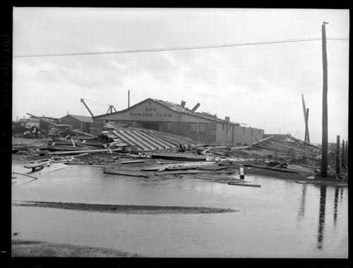 | Roof torn off the Don Rowing Club in May 19th, 1940 storm 84 years ago - Sunday, May 19, 1940 - Harbourfront at 29 Stadium Road south of Lake Shore Blvd West Link to archive record - Map location (From Archives of Ontario) |
| 1940 | 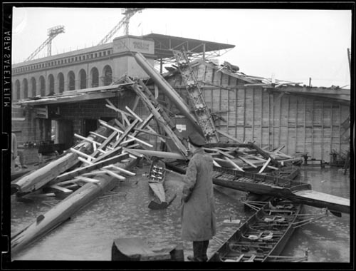 | May 19th storm damage at the Don Rowing Club with Maple Leaf Baseball stadium in background 84 years ago - Monday, May 20, 1940 - Harbourfront at 29 Stadium Road south of Lake Shore Blvd West Link to archive record - Map location (From Archives of Ontario) |
| 1963 |  | Gardiner Expressway under construction at Jarvis Street, east side, looking northeast from Lake Shore Boulevard East 61 years ago - 1963 - Harbourfront at 10 Lower Jarvis Street s.e. corner at Lakeshore Blvd Link to archive record - Map location (From the City of Toronto Archives) |