There are a wonderful set of Toronto historic photos available online, here are all the photos that I could find from around the Sunnybrook Park area in Toronto, Ontario, Canada.
| 1928 |
 | River in Kilgour Park (Sunnybrook Park)
96 years ago - Wednesday, October 3, 1928
- Sunnybrook Park at 1132 Leslie Street at Eglinton Ave East
Max temp: 18.3°C - Min temp: 6.1°C (weather details)
Link to archive record
- Map location
(From the City of Toronto Archives) |
| 1928 |
 | River and winding road in Kilgour Park (Sunnybrook park)
96 years ago - Wednesday, October 3, 1928
- Sunnybrook Park at 1132 Leslie Street at Eglinton Ave East
Max temp: 18.3°C - Min temp: 6.1°C (weather details)
Link to archive record
- Map location
(From the City of Toronto Archives) |
| 1935 |
 | Proposed open shelter addition to lavatory bldg., Sunnybrook Park for the Parks Dept.
(Categorized under: Architectural drawings )
89 years ago - Thursday, April 11, 1935
- Sunnybrook Park at 1132 Leslie Street at Eglinton Ave East
Max temp: 12.2°C - Min temp: 5.0°C (weather details)
Link to archive record
- Map location
(From the City of Toronto Archives) |
| 1947 |
 | Sunnybrook farm, East York Twp : exterior view of the barns and stables
77 years ago - 1947 - Sunnybrook Park at 1132 Leslie Street at Eglinton Ave East
Link to archive record
- Map location
(From the City of Toronto Archives) |
| 1948 |
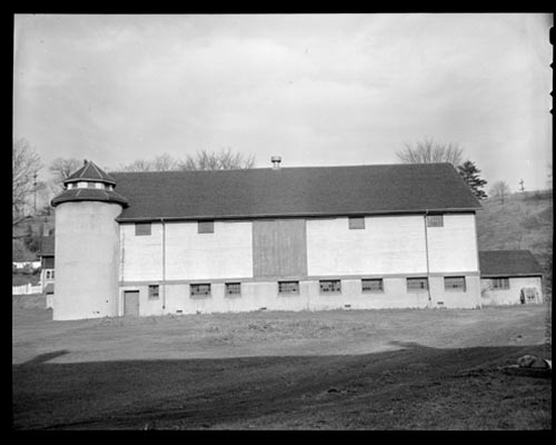 | Exterior view of a barn at Sunnybrook Farm
76 years ago - Friday, December 3, 1948
- Sunnybrook Park at 1132 Leslie Street at Eglinton Ave East
Max temp: 11.1°C - Min temp: 0.6°C (weather details)
Link to archive record
- Map location
(From Archives of Ontario) |