Historic photos from around Riverdale park, TorontoOn either side of the Don River, just south of Bloor Street and the Danforth, is Riverdale Park. Divided by the Don Valley Parkway (DVP), Riverdale Park East has a running track, three soccer fields, and a baseball diamond. This half of the park was originally owned by John Scadding (who's 1840 cabin from this area was moved to the CNE grounds). It has long been a popular tobogganing site in the winter, and has been used for military parades as well as sports. Riverdale Park West is directly south of the Toronto Necropolis Cemetery, with the Riverdale Farm (previously the Riverdale Zoo) on the far west side of the parkList of all areas in Toronto or take a look at the historic photos by date. New! You can now access the photos by street address A subset of the photos have also been arranged by subject. Tweet |
| 1872 |  | Henry Langley sketch: Chapel, Superintendants Lodge and Toronto Necropolis; elevations, plans and sections (Categorized under: Architectural drawings ) 152 years ago - 1872 - Riverdale park Link to archive record - Map location (From Archives of Ontario) |
| 1878 |  | Castle Frank history - from the book Toronto of Old 146 years ago - 1878 - Riverdale park Link to archive record - Map location |
| 1878 | | Drumsnab Estate overlooking the Don River from the book Toronto of Old 146 years ago - 1878 - Riverdale park Link to archive record - Map location |
| 1895 |  | East end of Winchester Street showing Belt Line - now in RIverdale Park (Categorized under: Belt Line trail ) 129 years ago - 1895 - Riverdale park at 201 Winchester Street Link to archive record - Map location (From the City of Toronto Archives) |
| 1895 |  | Winchester Street bridge over the Don River and Belt Line (Categorized under: Belt Line trail ) 129 years ago - 1895 - Riverdale park at 201 Winchester Street Link to archive record - Map location (From the City of Toronto Archives) |
| 1899 |  | After the breaking up of the Don River : entrance to Rosedale Creek sewer 125 years ago - Friday, February 24, 1899 - Riverdale park Max temp: -3.3°C - Min temp: -11.7°C (weather details) Link to archive record - Map location (From the City of Toronto Archives) |
| 1900 |  | After the breakup of the Don River looking north from Gerrard Street bridge showing flooding in Riverdale Park East - Toronto Necropolis in distance 124 years ago - Friday, February 9, 1900 - Riverdale park Max temp: 8.9°C - Min temp: -6.1°C (weather details) Link to archive record - Map location (From the City of Toronto Archives) |
| 1905 | 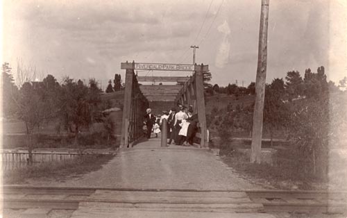 | Bridge over the Don River leading to the zoo. Childrens Hospital on hill to the right. Don Jail beyond that. 119 years ago - 1905 - Riverdale park Link to archive record - Map location (From Archives of Ontario) |
| 1907 |  | Carrying dynamite to blow up Riverdale Park, Broadview Avenue 117 years ago - 1907 - Riverdale park Link to archive record - Map location (From the City of Toronto Archives) |
| 1912 |  | Standing on the bridge over the Don looking west to Riverdale park 112 years ago - Saturday, May 11, 1912 - Riverdale park Max temp: 20.6°C - Min temp: 8.3°C (weather details) Link to archive record - Map location (From the City of Toronto Archives) |
| 1912 |  | Riverdale Park : looking north on east side of Don River 112 years ago - Saturday, May 11, 1912 - Riverdale park Max temp: 20.6°C - Min temp: 8.3°C (weather details) Link to archive record - Map location (From the City of Toronto Archives) |
| 1912 |  | Riverdale Park : looking northwest from near Gerrard St 112 years ago - Saturday, May 11, 1912 - Riverdale park Max temp: 20.6°C - Min temp: 8.3°C (weather details) Link to archive record - Map location (From the City of Toronto Archives) |
| 1912 |  | Riverdale Zoo Park : duck pond when nearly dry 112 years ago - Saturday, May 11, 1912 - Riverdale park Max temp: 20.6°C - Min temp: 8.3°C (weather details) Link to archive record - Map location (From the City of Toronto Archives) |
| 1912 |  | General view of Riverdale Park east side of Don river and playing field 112 years ago - Saturday, November 9, 1912 - Riverdale park Max temp: 8.9°C - Min temp: 2.8°C (weather details) Link to archive record - Map location (From the City of Toronto Archives) |
| 1913 |  | Riverdale Park free skating rink with the Necropolis in the background 111 years ago - 1913 - Riverdale park Link to archive record - Map location (From the City of Toronto Archives) |
| 1914 |  | Winter tobogganing along Broadview 110 years ago - Saturday, January 17, 1914 - Riverdale park Max temp: 0.6°C - Min temp: -10.0°C (weather details) Link to archive record - Map location (From the City of Toronto Archives) |
| 1914 | Looking across Riverdale Zoo to a general view of games in Riverdale Park 110 years ago - Saturday, July 4, 1914 - Riverdale park at 375 Sumach Street Link to archive record - Map location (From the Library and Archives Canada) |
|
| 1914 |  | Group of men on site, from Drumsnab Road 110 years ago - Friday, July 10, 1914 - Riverdale park Max temp: 29.4°C - Min temp: 16.1°C (weather details) Link to archive record - Map location (From the City of Toronto Archives) |
| 1917 |  | Riverdale Park foot bridge looking west, (Watchmans House left corner) 107 years ago - Friday, June 1, 1917 - Riverdale park Max temp: 21.7°C - Min temp: 11.7°C (weather details) Link to archive record - Map location (From the City of Toronto Archives) |
| 1922 |  | Riverdale Zoo Park - waterfowl in the lower pond 102 years ago - Friday, May 12, 1922 - Riverdale park Max temp: 19.4°C - Min temp: 10.6°C (weather details) Link to archive record - Map location (From the City of Toronto Archives) |
| 1922 |  | Riverdale Park - panorama looking east 102 years ago - Saturday, May 13, 1922 - Riverdale park Max temp: 20.6°C - Min temp: 7.8°C (weather details) Link to archive record - Map location (From the City of Toronto Archives) |
| 1923 |  | The elephants at the Riverdale Zoo, Toronto 101 years ago - 1923 - Riverdale park Link to archive record - Map location (From Archives of Ontario) |
| 1924 |  | Panorama of lawn tennis courts in Riverdale Park, east side 100 years ago - Saturday, August 16, 1924 - Riverdale park Max temp: 22.8°C - Min temp: 13.9°C (weather details) Link to archive record - Map location (From the City of Toronto Archives) |
| 1925 | 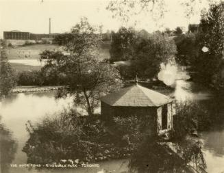 | Riverdale Park - looking north-east across the duck pond 99 years ago - 1925 - Riverdale park Link to archive record - Map location (From the Toronto Public Library Still not back as of March 2024) |
| 1925 |  | Riverdale Zoo enclosures (Motor Coach Department) 99 years ago - Friday, May 29, 1925 - Riverdale park Max temp: 19.4°C - Min temp: 10.0°C (weather details) Link to archive record - Map location (From the City of Toronto Archives) |
| 1926 |  | Polar bear cubs, Riverdale Zoo 98 years ago - Wednesday, May 26, 1926 - Riverdale park Max temp: 16.7°C - Min temp: 6.7°C (weather details) Link to archive record - Map location (From the City of Toronto Archives) |
| 1955 | 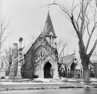 | Necropolis Cemetery - High Victorian Gothic architecture by Henry Langley - 200 Winchester St. 69 years ago - Sunday, December 25, 1955 - Riverdale park Max temp: 2.2°C - Min temp: -1.7°C - 4.0cm of snow on the ground (weather details) Link to archive record - Map location (From the Toronto Public Library Still not back as of March 2024) |