Historic photos from around Regal Heights, TorontoThere are a wonderful set of Toronto historic photos available online, here are all the photos that I could find from around the Regal Heights area in Toronto, Ontario, Canada.List of all areas in Toronto or take a look at the historic photos by date. New! You can now access the photos by street address A subset of the photos have also been arranged by subject. Tweet |
| 1920 |  | Regal Road Public School (Categorized under: Schools ) 104 years ago - 1920 - Regal Heights at 95 Regal Road Link to archive record - Map location (From the City of Toronto Archives) |
| 1926 | 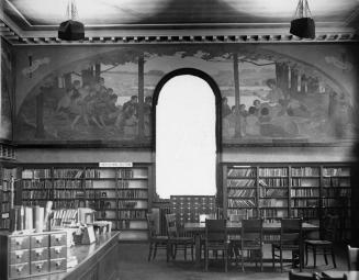 | 1926 Toronto Reid murals Public Library; Dufferin-St. Clair Branch, Dufferin St., e. side, between Rosemount &; St. Clair Aves.; Interior. 98 years ago - 1926 - Regal Heights at 1625 Dufferin Street Link to archive record - Map location (From the Toronto Public Library Still not back as of March 2024) |
| 1946 |  | Northwest corner Oakwood Avenue and Regal Road - steps washed away 78 years ago - Thursday, August 29, 1946 - Regal Heights at 44 Oakwood Ave Max temp: 17.2°C - Min temp: 10.0°C (weather details) Link to archive record - Map location (From the City of Toronto Archives) |
| 1946 |  | Oakwood and Regal Road - retaining wall 78 years ago - Monday, November 4, 1946 - Regal Heights at 47 Oakwood Ave Max temp: 12.8°C - Min temp: 6.7°C (weather details) Link to archive record - Map location (From the City of Toronto Archives) |