Historic photos from around Playter Estates, TorontoThere are a wonderful set of Toronto historic photos available online, here are all the photos that I could find from around the Playter Estates area in Toronto, Ontario, Canada.List of all areas in Toronto or take a look at the historic photos by date. New! You can now access the photos by street address A subset of the photos have also been arranged by subject. Tweet |
| 1905 | 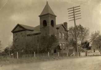 | Old Chester Public School on Broadview Ave. now part of the Estonian House 119 years ago - 1905 - Playter Estates Link to archive record - Map location (From the Toronto Public Library Still not back as of March 2024) |
| 1923 |  | Erindale Loop - Broadview, looking north 101 years ago - Tuesday, June 5, 1923 - Playter Estates Max temp: 31.1°C - Min temp: 17.2°C (weather details) Link to archive record - Map location (From the City of Toronto Archives) |
| 1926 |  | Northwest corner Pretoria and Ellerbeck 98 years ago - Tuesday, July 27, 1926 - Playter Estates Max temp: 24.4°C - Min temp: 15.0°C (weather details) Link to archive record - Map location (From the City of Toronto Archives) |
| 1926 |  | Southwest corner Playter and Butternut (hedge) 98 years ago - Friday, July 30, 1926 - Playter Estates Max temp: 25.6°C - Min temp: 15.0°C (weather details) Link to archive record - Map location (From the City of Toronto Archives) |
| 1926 |  | Northwest corner Broadview and Chester Hill 98 years ago - Friday, December 3, 1926 - Playter Estates Max temp: -0.6°C - Min temp: -8.9°C - 3.0cm of snowfall (weather details) Link to archive record - Map location (From the City of Toronto Archives) |
| 1939 |  | 10, 12, 14 Eastmount Avenue overlooking Don Valley Ravine 85 years ago - Tuesday, December 26, 1939 - Playter Estates at 10 Eastmount Ave Max temp: -4.4°C - Min temp: -8.9°C (weather details) Link to archive record - Map location (From the City of Toronto Archives) |
| 1939 |  | Looking down into the ravine at the railway tracks behind 10 Eastmount Avenue 85 years ago - Tuesday, December 26, 1939 - Playter Estates Max temp: -4.4°C - Min temp: -8.9°C (weather details) Link to archive record - Map location (From the City of Toronto Archives) |
| 1940 |  | Landslide into Don Ravine at 10-14 Eastmount Avenue 84 years ago - Wednesday, January 3, 1940 - Playter Estates Max temp: -1.7°C - Min temp: -8.9°C (weather details) Link to archive record - Map location (From the City of Toronto Archives) |
| 1940 |  | House propped up after landslide into Don River ravine - 10 Eastmount Avenue 84 years ago - Wednesday, January 3, 1940 - Playter Estates Max temp: -1.7°C - Min temp: -8.9°C (weather details) Link to archive record - Map location (From the City of Toronto Archives) |