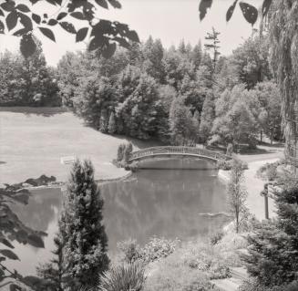
A wonderful public park and set of walking trails located at Lawrence Ave West and Leslie Street.
After the war of 1812 the land was owned by the Scottish weaver Alexander Milne for wool and saw mills, then turned into a 'country estate' by Rupert E. Edwards in 1944. He called the area Springbook Farms. By 1955 it sold to the City for $160,000 - well below market rate - to be turned into a public park.
| 1950 |
 | Areal photo of the gardens property in the 1950s 76 years ago - 1950 - Edward Gardens at 755 Lawrence Ave East s.w. corner at Leslie Street
Link to archive record
- Map location
(From the City of Toronto Archives) |
| 1955 |
 | A bridge in Edwards Gardens, Originally Rupert Edwards Springbrook Farm
(Categorized under: Bridges )
71 years ago - Sunday, July 3, 1955
- Edward Gardens at 755 Lawrence Ave East s.w. corner at Leslie Street
Max temp: 30.0°C - Min temp: 18.9°C (weather details) Link to archive record
- Map location
(From the Toronto Public Library) |
| 1955 |
 | Milne Cemetery in Edwards Gardens 71 years ago - Sunday, July 3, 1955
- Edward Gardens at 755 Lawrence Ave East s.w. corner at Leslie Street
Max temp: 30.0°C - Min temp: 18.9°C (weather details) Link to archive record
- Map location
(From the Toronto Public Library) |
| 1956 |
 | Opening day Edwards Gardens, June 23, 1956, Chirnside family, and fountain looking towards original farm house 70 years ago - Saturday, June 23, 1956
- Edward Gardens at 755 Lawrence Ave East s.w. corner at Leslie Street
Link to archive record
- Map location
(From the Toronto Public Library) |
| 1957 |
 | People enjoying the lawns, bridge, and flowers in Edwards Gardens 69 years ago - Sunday, September 1, 1957
- Edward Gardens at 755 Lawrence Ave East s.w. corner at Leslie Street
Link to archive record
- Map location
(From the Toronto Public Library) |
| 1958 |
 | Edwards Gardens in the winter, looking north up Wilket Creek towards Lawrence Ave. East 68 years ago - 1958 - Edward Gardens at 755 Lawrence Ave East s.w. corner at Leslie Street
Link to archive record
- Map location
(From the Toronto Public Library) |
| 1958 |
 | Edwards Gardens bridge and stream
(Categorized under: Bridges )
68 years ago - Sunday, August 3, 1958
- Edward Gardens at 755 Lawrence Ave East s.w. corner at Leslie Street
Link to archive record
- Map location
(From the City of Toronto Archives) |
| 1959 |
 | Bridge in Edwards Gardens, Toronto
(Categorized under: Bridges )
67 years ago - 1959 - Edward Gardens at 755 Lawrence Ave East s.w. corner at Leslie Street
Link to archive record
- Map location
(From Archives of Ontario) |
| 1960 |
 | Mike Bela Park in North York at the south end of Banbury Road 66 years ago - 1960 - Edward Gardens at 1 Banbury Road n.w. corner of Leslie and Lawrence Ave East
Link to archive record
- Map location
(From the City of Toronto Archives) |
| 1966 |
 | Wilket Creek horseback riding in the bright yellow fall trees 60 years ago - 1966 - Edward Gardens at 755 Lawrence Ave East s.w. corner at Leslie Street
Link to archive record
- Map location
(From the City of Toronto Archives) |
| 1967 |
 | Colour photograph of the tulips in bloom by the river and bridge.
(Categorized under: Bridges )
59 years ago - 1967 - Edward Gardens at 755 Lawrence Ave East s.w. corner at Leslie Street
Link to archive record
- Map location
(From the City of Toronto Archives) |
| 1967 |
 | Tulips and bridge in the Edwards Gardens in springtime 59 years ago - 1967 - Edward Gardens at 755 Lawrence Ave East s.w. corner at Leslie Street
Link to archive record
- Map location
(From the City of Toronto Archives) |
| 1970 |
 | Edwards Gardens pond, bridge, and rock waterfall 56 years ago - Wednesday, October 14, 1970
- Edward Gardens at 755 Lawrence Ave East s.w. corner at Leslie Street
Link to archive record
- Map location
(From the Toronto Public Library) |
| 1983 |
 | Edwards Gardens mini waterfalls in May, 1983 43 years ago - Wednesday, May 11, 1983
- Edward Gardens at 755 Lawrence Ave East s.w. corner at Leslie Street
Link to archive record
- Map location
(From the Toronto Public Library) |