Historic Toronto photos from October 4There are a number of great web sites that provide historic photos from around Toronto. As I was collecting them for an interactive historic map of the city I realized that it was also interesting to find photos that were taken around the current time of the year.If you'd like to see photos from today, you can always load this page without parameters to see the last few days worth of photos. You can also see all the historic photos for a given neighbourhood. A subset of the photos have also been arranged by subject. Tweet |
| 1955 | 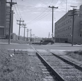 | G.T.R. Belt Line, looking e. across Bathurst St., betw. Shallmar Blvd. & Roselawn Ave. (Categorized under: Belt Line trail ) 69 years ago - Tuesday, October 4, 1955 - Forest Hill Max temp: 25.0°C - Min temp: 10.0°C (weather details) Link to archive record - Map location (From the Toronto Public Library Still not back as of March 2024) |
| 1957 | Crowds around the Avro Arrow unveiling at Pearson Airport - RL 201 - tail number 25201 67 years ago - Friday, October 4, 1957 - Malton at 6301 Silver Dart Drive Link to archive record - Map location (From the Library and Archives Canada) |
|