Historic Toronto photos from October 23
There are a number of great web sites that provide historic photos from around Toronto. As I was collecting them for an interactive historic map of the city I realized that it was also interesting to find photos that were taken around the current time of the year.If you'd like to see photos from today, you can always load this page without parameters to see the last few days worth of photos.
You can also see all the historic photos for a given neighbourhood. A subset of the photos have also been arranged by subject.
Tweet| 1861 | 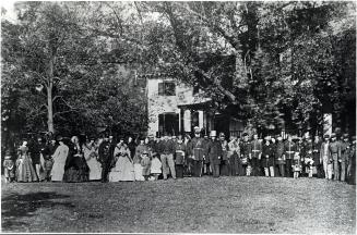 | Rosedale garden party by William Botsford Jarvis - Rosedale Rd., w. side, between Avondale Rd. and Cluny Ave. 163 years ago - Wednesday, October 23, 1861 - Rosedale Max temp: 8.3°C - Min temp: 6.7°C (weather details) Link to archive record - Map location (From the Toronto Public Library Still not back as of March 2024) |
| 1914 |  | Lake Simcoe Ice Co. property, south side of 83 Esplanade East - near foot of Frederick Street 110 years ago - Friday, October 23, 1914 - St. Lawrence Max temp: 17.2°C - Min temp: 5.0°C (weather details) Link to archive record - Map location (From the City of Toronto Archives) |
| 1925 |  | Massey Hall interior during a W. L. M. King meeting (Categorized under: Massey Hall ) 99 years ago - Friday, October 23, 1925 - Garden District Max temp: 7.8°C - Min temp: -1.1°C (weather details) Link to archive record - Map location (From the City of Toronto Archives) |
| 1955 | 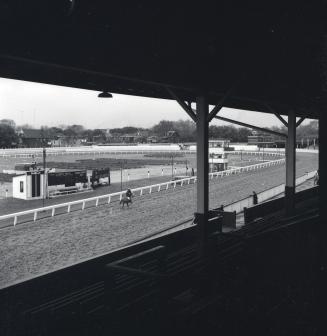 | Dufferin Park Race Track 1894-1955, Dufferin St., w. side, between Muir Ave. & Croatia St.; looking n.w. 69 years ago - Sunday, October 23, 1955 - Brockton Village at 900 Dufferin Street Max temp: 17.8°C - Min temp: 4.4°C (weather details) Link to archive record - Map location (From the Toronto Public Library Still not back as of March 2024) |
| 1955 | 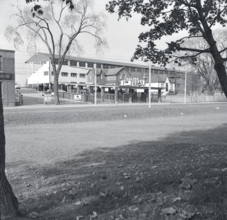 | Dufferin Park Race Track, looking w. across Dufferin St. from Dufferin Grove Park 69 years ago - Sunday, October 23, 1955 - Brockton Village at 900 Dufferin Street Max temp: 17.8°C - Min temp: 4.4°C (weather details) Link to archive record - Map location (From the Toronto Public Library Still not back as of March 2024) |
| 1958 |  | Royce Avenue Presbyterian Church 1543-1551 Dupont Street (at Perth) 66 years ago - Thursday, October 23, 1958 - The Junction Max temp: 15.0°C - Min temp: 11.7°C (weather details) Link to archive record - Map location (From the City of Toronto Archives) |