Historic Toronto photos from June 7
There are a number of great web sites that provide historic photos from around Toronto. As I was collecting them for an interactive historic map of the city I realized that it was also interesting to find photos that were taken around the current time of the year.If you'd like to see photos from today, you can always load this page without parameters to see the last few days worth of photos.
You can also see all the historic photos for a given neighbourhood. A subset of the photos have also been arranged by subject.
Tweet| 1899 | 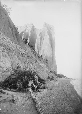 | Looking up at The Dutch Church along the Scarborough Bluffs 125 years ago - Wednesday, June 7, 1899 - Scarborough Bluffs Max temp: 29.4°C - Min temp: 17.2°C (weather details) Link to archive record - Map location (From the Toronto Public Library Still not back as of March 2024) |
| 1911 |  | Wilton Cres. west of Sherbourne -track construction 113 years ago - Wednesday, June 7, 1911 - Garden District Max temp: 17.8°C - Min temp: 11.7°C (weather details) Link to archive record - Map location (From the City of Toronto Archives) |
| 1911 |  | All Saints Church in distance at Wilton Cres. east of Sherbourne 113 years ago - Wednesday, June 7, 1911 - Garden District Max temp: 17.8°C - Min temp: 11.7°C (weather details) Link to archive record - Map location (From the City of Toronto Archives) |
| 1926 |  | Loring/Wyle Parkette at old Moore Park streetcar loop (Categorized under: Streetcars and buses ) 98 years ago - Monday, June 7, 1926 - Moore Park Max temp: 21.7°C - Min temp: 7.2°C (weather details) Link to archive record - Map location (From the City of Toronto Archives) |
| 1926 |  | Rosedale Loop west side of Sherbourne Street, looking west, (Way Department) 98 years ago - Monday, June 7, 1926 - Rosedale Max temp: 21.7°C - Min temp: 7.2°C (weather details) Link to archive record - Map location (From the City of Toronto Archives) |
| 1926 |  | Front lawn at 91 Hillsdale Avenue W., just east of Colin Ave. 98 years ago - Monday, June 7, 1926 - Chaplin Estates at 91 Hillsdale Ave West east of Colin Avenue Max temp: 21.7°C - Min temp: 7.2°C (weather details) Link to archive record - Map location (From the City of Toronto Archives) |
| 1939 |  | 436 Wellesley rear 85 years ago - Wednesday, June 7, 1939 - Riverdale at 436 Wellesley Street East Max temp: 23.3°C - Min temp: 10.6°C (weather details) Link to archive record - Map location (From the City of Toronto Archives) |
| 1939 |  | 436 Wellesley rear (June 13) 85 years ago - Wednesday, June 7, 1939 - Riverdale at 436 Wellesley Street East Max temp: 23.3°C - Min temp: 10.6°C (weather details) Link to archive record - Map location (From the City of Toronto Archives) |