Davenport and The Hill
Davenport was one of the first of many mansions built on the escarpment which now overlooks Davenport Avenue. John McGill built the first home there in the late 1790's, naming it after Major Davenport who served with him at Fort York. Colonel Joseph Wells bought Davenport in 1821 and built a larger home. The Wells family lived in Davenport until it was sold in 1913 when the house was demolished and the land subdivided for houses.The escarpment created by the old shoreline of Lake Iroquois was a natural dividing line as Toronto grew. There has been an east/west route for many years running just south of the escarpment - first a portage trail from the Humber River to the Don river, then a road known as Plank Road, and finally Davenport Ave. The mansions and grand homes on "Davenport Hill" or just "The Hill" overlooked the lake and the growing city. Running from west to east, the following houses and estates graced "The Hill" over the years:
- Bracondale Hill - in Hillcrest Park
- Davenport
- Casa Loma
- Spadina House (now Spadina Museum)
- Ardwold (previously Ravenswood 1867-1909 Anne Arthurs)
- Glen edyth (previously Russell Hill - 1881-1872)
- Rathnelly - built in 1830 by William McMaster
- Benvenuto
- Oaklands
List of all subjects. You can also see all the historic photos for a given neighbourhood. We also have a list of all the photos arranged by date.
And you can also go up a level to see the other photos we've put under the category of Estates_and_Houses photos.
| 1894 | 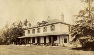 | Davenport - Wells Residence, n. of Davenport Rd., e. of Bathurst St. - built in the 1820s 130 years ago - The Annex - 1894 Link to archive record - Map location (From the Toronto Public Library) |
| 1900 |  | Davenport - built by Colonel Joseph Wells in the 1820s, demolished 1913. North/east of Bathurst and Davenport 124 years ago - The Annex - 1900 Link to archive record - Map location (From Archives of Ontario) |