Architectural Sketches and DrawingsThere are many architectural drawings of proposed, and built, structures around Toronto. |
List of all subjects. You can also see all the historic photos for a given neighbourhood. We also have a list of all the photos arranged by date.
| 1830 | 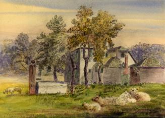 | Watercolour of proposed Caer Howell buildings by W. D. Powell 194 years ago - Discovery District - 1830 Link to archive record - Map location (From the Toronto Public Library) |
| 1845 |  | St. Michael's Roman Catholic Cathedral plans and photos 179 years ago - Garden District - 1845 Link to archive record - Map location (From the Toronto Public Library) |
| 1845 | Pencil sketch of Kings College by Catherine Beaven 179 years ago - Queens Park - 1845 Link to archive record - Map location (From the University of Toronto Archives) |
|
| 1850 |  | Stain Glass Window sketches for St. James Cathedral - Cumberland and Storm 174 years ago - St. Lawrence - 1850 Link to archive record - Map location (From Archives of Ontario) |
| 1858 |  | Sketch of Osgoode Hall library and dome; interior perspective 166 years ago - City Hall - 1858 Link to archive record - Map location (From Archives of Ontario) |
| 1865 | | Completion of pinnacles of St. Michael's Cathedral - Henry Langley 159 years ago - Garden District - Thursday, December 28, 1865 Max temp: 1.7°C - Min temp: -2.8°C - 0.3cm of snowfall (weather details) Link to archive record - Map location (From the Toronto Public Library) |
| 1865 | | Plan for completion of Tower and Spire St. Michael's Roman Catholic Cathedral - Henry Langley 159 years ago - Garden District - Thursday, April 27, 1865 Max temp: 13.9°C - Min temp: 5.0°C (weather details) Link to archive record - Map location (From the Toronto Public Library) |
| 1870 | 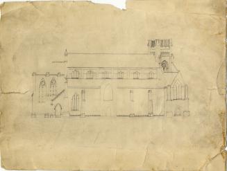 | Sketch of St. James' Anglican Cathedral by George Taylor Denison II (1816-1873) 154 years ago - St. Lawrence - 1870 Link to archive record - Map location (From the Toronto Public Library) |
| 1871 | | Longitudinal Section, Transverse Section, Rear Elevation Parliament Street Methodist Church 153 years ago - Regent Park - Thursday, April 27, 1871 Max temp: 11.1°C - Min temp: 4.4°C (weather details) Link to archive record - Map location (From the Toronto Public Library) |
| 1871 | | Sketches: West Elevation, South Elevation of Parliament Street Methodist Church 153 years ago - Regent Park - Thursday, April 27, 1871 Max temp: 11.1°C - Min temp: 4.4°C (weather details) Link to archive record - Map location (From the Toronto Public Library) |
| 1872 | | Parliament Street Methodist Church plans - Henry Langley 152 years ago - Regent Park - Sunday, January 21, 1872 Max temp: -1.1°C - Min temp: -3.9°C - 0.8cm of snowfall (weather details) Link to archive record - Map location (From the Toronto Public Library) |
| 1872 |  | Henry Langley sketch: Chapel, Superintendants Lodge and Toronto Necropolis; elevations, plans and sections 152 years ago - Riverdale park - 1872 Link to archive record - Map location (From Archives of Ontario) |
| 1873 | Architectural drawing of Old Knox College at 1 Spadina Crescent - cross section and west elevation 151 years ago - University of Toronto (U of T) - 1873 Link to archive record - Map location (From the University of Toronto Archives) |
|
| 1874 | | Sketches: Inside and Outside Elevation, spire, etc... of Jarvis Street Baptist Church 150 years ago - Garden District - Tuesday, April 28, 1874 Max temp: 4.4°C - Min temp: -2.2°C (weather details) Link to archive record - Map location (From the Toronto Public Library) |
| 1874 | | Jarvis Street Baptist Church South Elevation - Henry Langley 150 years ago - Garden District - Tuesday, April 28, 1874 Max temp: 4.4°C - Min temp: -2.2°C (weather details) Link to archive record - Map location (From the Toronto Public Library) |
| 1875 | | Jarvis Street Baptist Church by Henry Langley 149 years ago - Garden District - 1875 Link to archive record - Map location (From the Toronto Public Library) |
| 1882 | 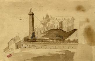 | Demolishing the waterworks tower at St. Georges Reservoir - Dundas St. W., n.e. cor. Huron St. 142 years ago - Grange Park - 1882 Link to archive record - Map location (From the Toronto Public Library) |
| 1884 | | Design for Proposed Enlargement of the Parliament Street Methodist Church 140 years ago - Regent Park - Wednesday, August 6, 1884 Max temp: 22.8°C - Min temp: 10.6°C (weather details) Link to archive record - Map location (From the Toronto Public Library) |
| 1889 |  | Victoria College; flank elevation - east - by William G. Storm 135 years ago - University of Toronto (U of T) - 1889 Link to archive record - Map location (From Archives of Ontario) |
| 1890 | 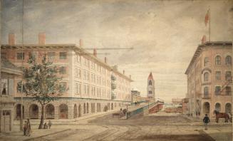 | Walker House on the right, with the proposed Canadian Pacific Railway Station on the left - York St., e. side, at Esplanade W.; looking s. down York St. from Front St. W. 134 years ago - Financial District - 1890 Link to archive record - Map location (From the Toronto Public Library) |
| 1895 | 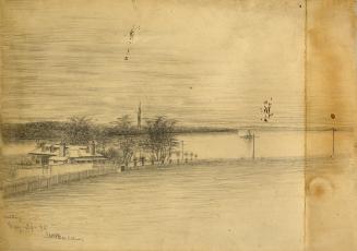 | Old Officers Quarters, Penetanguishene, Ontario 129 years ago - Penetanguishene Bay - Friday, May 24, 1895 Max temp: 23.9°C - Min temp: 10.6°C (weather details) Link to archive record - Map location (From the Toronto Public Library) |
| 1897 | 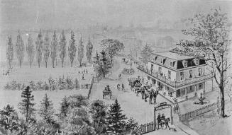 | Sketch of Caer Howell Hotel in the winter with horse drawn carriages and distinctive gate 127 years ago - Discovery District - 1897 Link to archive record - Map location (From the Toronto Public Library) |
| 1899 | 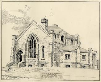 | Sketch of the Church of the Covenant before west section added - Avenue Road and Roxborough 125 years ago - Summerhill - 1899 Link to archive record - Map location (From the Toronto Public Library) |
| 1905 | 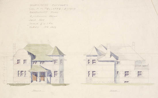 | E. J. Lennox sketches of workmens cottages at H. M. Pellatt estate - front and side elevations 119 years ago - Casa Loma - 1905 Link to archive record - Map location (From Archives of Ontario) |
| 1905 | 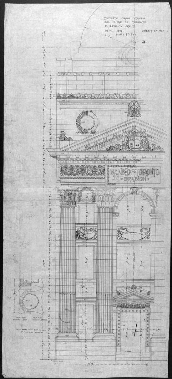 | Drawings of Bank of Toronto branch office - E. J. Lennox architect - 205 Yonge 119 years ago - Downtown - 1905 Link to archive record - Map location (From Archives of Ontario) |
| 1912 |  | Tracing of the Toronto high level pumping station 112 years ago - Republic of Rathnelly - Saturday, February 3, 1912 Max temp: -7.2°C - Min temp: -15.0°C (weather details) Link to archive record - Map location (From the City of Toronto Archives) |
| 1914 |  | Sketch of proposed stone gates at Dufferin Grove South from Gladstone Avenue (Feb 14, 1913 is original photo) 110 years ago - Dufferin Grove - Saturday, February 7, 1914 Max temp: 2.8°C - Min temp: -7.8°C (weather details) Link to archive record - Map location (From the City of Toronto Archives) |
| 1923 |  | Sketch for proposed shelter at Stanley Park 101 years ago - Stanley Park - 1923 Link to archive record - Map location (From the City of Toronto Archives) |
| 1923 |  | Sketch for new shelter at Stanley Park 101 years ago - Stanley Park - 1923 Link to archive record - Map location (From the City of Toronto Archives) |
| 1924 |  | Sketch and floorplan of Rosedale Park shelter 100 years ago - Rosedale - 1924 Link to archive record - Map location (From the City of Toronto Archives) |
| 1926 |  | Proposed new lavatories and shelter at Reservoir Park 98 years ago - Rosehill - 1926 Link to archive record - Map location (From the City of Toronto Archives) |
| 1927 | 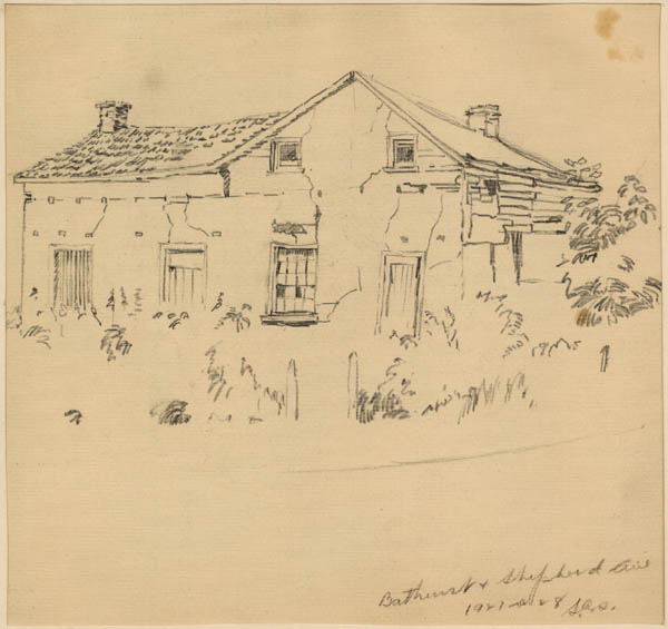 | Pencil sketch of derelict building by Stewart C. Shaw at Bathurst and Sheppard Sts. 97 years ago - Bathurst Manor - 1927 Link to archive record - Map location (From Archives of Ontario) |
| 1927 |  | C. S. Shaw sketch of a derelict building, Bathurst and Sheppard Sts., Toronto 97 years ago - Bathurst Manor - 1927 Link to archive record - Map location (From Archives of Ontario) |
| 1930 |  | Service Building - south elevation - blueprints - R.C. Harris Water Treatment Plant 94 years ago - Fallingbrook - 1930 Link to archive record - Map location |
| 1930 |  | Sketch of a Cow gate outside Osgoode Hall on Queen Street West at University Ave 94 years ago - City Hall - 1930 Link to archive record - Map location (From Archives of Ontario) |
| 1930 |  | Filtration Building - south elevation - blueprints - R.C. Harris Water Treatment Plant 94 years ago - Fallingbrook - 1930 Link to archive record - Map location |
| 1931 |  | Colour sketch of a gate for the Kew Beach athletic field 93 years ago - The Beaches - 1931 Link to archive record - Map location (From the City of Toronto Archives) |
| 1932 |  | Sketch of the Destructor on Symes Rd. for the City of Toronto, Department of Buildings 92 years ago - Harwood - Friday, December 23, 1932 Max temp: 5.6°C - Min temp: 0.0°C (weather details) Link to archive record - Map location (From the City of Toronto Archives) |
| 1933 |  | Drawing of the fieldhouse in Grange Park for the Dept. of Parks 91 years ago - Art Gallery of Ontario - Thursday, November 9, 1933 Max temp: 1.1°C - Min temp: -2.2°C - 9.1cm of snowfall (weather details) Link to archive record - Map location (From the City of Toronto Archives) |
| 1934 |  | Proposed lavatory building, Clarke Beach Park for the Parks Department 90 years ago - Cherry Beach - Thursday, December 13, 1934 Max temp: 0.0°C - Min temp: -6.1°C - 1.3cm of snowfall (weather details) Link to archive record - Map location (From the City of Toronto Archives) |
| 1934 |  | Suggestions for railings, Lytton Park, for the Parks Dept. 90 years ago - Lytton Park - Wednesday, October 10, 1934 Max temp: 12.2°C - Min temp: 2.8°C (weather details) Link to archive record - Map location (From the City of Toronto Archives) |
| 1934 |  | Sketch of proposed bathing station for Sunnyside Beach 90 years ago - Sunnyside Park - Monday, January 8, 1934 Max temp: 3.9°C - Min temp: 0.6°C - 0.5cm of snowfall (weather details) Link to archive record - Map location (From the City of Toronto Archives) |
| 1934 |  | Pencil sketch of proposed fieldhouse, Wanless Park, for the Parks Dept. 90 years ago - Wanless Park - Thursday, November 8, 1934 Max temp: 6.7°C - Min temp: 0.6°C (weather details) Link to archive record - Map location (From the City of Toronto Archives) |
| 1935 |  | Alexandra Gates - drawing of an aerial view of Avenue Road and Bloor 89 years ago - Royal Ontario Museum - Thursday, January 17, 1935 Max temp: 3.9°C - Min temp: -5.6°C (weather details) Link to archive record - Map location (From the City of Toronto Archives) |
| 1935 |  | Scheme 1, proposed widening Alexandra gates, Avenue Rd. and Bloor St. W. for the Parks Dept. 89 years ago - Royal Ontario Museum - Thursday, January 17, 1935 Max temp: 3.9°C - Min temp: -5.6°C (weather details) Link to archive record - Map location (From the City of Toronto Archives) |
| 1935 |  | Alexandra Gates, colours for railings and lamps 89 years ago - Royal Ontario Museum - Friday, March 8, 1935 Max temp: -2.8°C - Min temp: -12.2°C (weather details) Link to archive record - Map location (From the City of Toronto Archives) |
| 1935 |  | Aerial view sketch of Wanless Park fieldhouse, Toronto 89 years ago - Wanless Park - 1935 Link to archive record - Map location (From the City of Toronto Archives) |
| 1935 |  | Suggested colour scheme, Clarke Beach lavatory building for the Parks Dept. 89 years ago - Cherry Beach - Wednesday, February 20, 1935 Max temp: -2.8°C - Min temp: -8.9°C (weather details) Link to archive record - Map location (From the City of Toronto Archives) |
| 1935 |  | Colour sketch of Alexandra Gates when it was on Avenue Road 89 years ago - Royal Ontario Museum - Monday, February 25, 1935 Max temp: -3.3°C - Min temp: -6.7°C - 7.6cm of snowfall (weather details) Link to archive record - Map location (From the City of Toronto Archives) |
| 1935 |  | Proposed open shelter addition to lavatory bldg., Sunnybrook Park for the Parks Dept. 89 years ago - Sunnybrook Park - Thursday, April 11, 1935 Max temp: 12.2°C - Min temp: 5.0°C (weather details) Link to archive record - Map location (From the City of Toronto Archives) |
| 1935 |  | Sketch of side elevation of the Wanless Park fieldhouse 89 years ago - Wanless Park - Thursday, March 7, 1935 Max temp: -2.2°C - Min temp: -6.1°C (weather details) Link to archive record - Map location (From the City of Toronto Archives) |
| 1936 |  | Perspective of inside area bounded by Dundas St. E., Sackville St., Oak St., and Sumach St., Toronto 88 years ago - Regent Park - 1936 Link to archive record - Map location (From the City of Toronto Archives) |
| 1940 |  | Wards Island Hotel, sketch of proposed remodelling 84 years ago - Toronto Island - 1940 Link to archive record - Map location (From the City of Toronto Archives) |
| 1946 |  | Carls-Rite Hotel on Front Street - built 1893 and known as the Grand Union, then Hotel Carls-Rite, finally the Hotel Barclay 78 years ago - Downtown - 1946 Link to archive record - Map location (From the City of Toronto Archives) |
| 1965 | 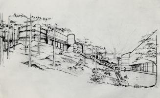 | Ontario Science Centre - sketch of the buildings on the side of the Don River ravine 59 years ago - Don Mills - Tuesday, April 27, 1965 Link to archive record - Map location (From the Toronto Public Library) |