Historic photos from around The Beaches, Toronto
The Beaches (or just 'The Beach') is a residential and tourist area along Lake Ontario east of downtown Toronto. The waterfront is divided up into four beach areas: Balmy Beach, Scarboro Beach, Kew Beach and Woodbine Beach (previously known as The Cut).European development started in 1793 when Alexander Aitken divided the area into lots on behalf of Lieutenant Governor John Simcoe. By the 1870's the area was connected to Toronto by streetcars and boats in the summer, and it became a popular summer daytrip from the city with a number of amusement parks.
West of The Beaches is Leslieville with Fallingbrook to the east. To the north is the Upper Beach.
List of all areas in Toronto or take a look at the historic photos by date. New! You can now access the photos by street address A subset of the photos have also been arranged by subject. Tweet
| 1885 | 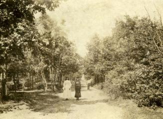 | Beech Ave. - out for a walk amongst the trees 139 years ago - 1885 - The Beaches Link to archive record - Map location (From the Toronto Public Library Still not back as of March 2024) |
| 1890 |  | Streetcar tracks and paving stones on Queen St east of Lee Ave 134 years ago - 1890 - The Beaches Link to archive record - Map location (From the City of Toronto Archives) |
| 1890 |  | Queen Street east of Lee Avenue in The Beaches 134 years ago - 1890 - The Beaches Link to archive record - Map location (From the City of Toronto Archives) |
| 1890 |  | Looking down to the lake from Queen Street east of Lee Avenue 134 years ago - 1890 - The Beaches Link to archive record - Map location (From the City of Toronto Archives) |
| 1900 | 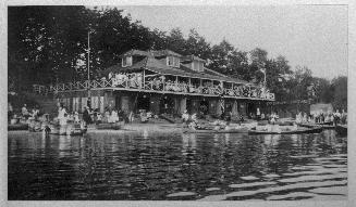 | Balmy Beach Club, Balmy Beach Park, foot of Beech Ave. people out enjoying the canoes 124 years ago - 1900 - The Beaches Link to archive record - Map location (From the Toronto Public Library Still not back as of March 2024) |
| 1904 |  | KEW Beach Grocery and Smith - Queen Street west of Lee Avenue 120 years ago - Saturday, February 20, 1904 - The Beaches at 2040 Queen Street East Max temp: -4.4°C - Min temp: -16.1°C (weather details) Link to archive record - Map location (From the City of Toronto Archives) |
| 1905 |  | Kew Beach fire hall - construction - main storey being built - now Toronto Fire Station 227 119 years ago - 1905 - The Beaches at 1904 Queen Street East Link to archive record - Map location (From the City of Toronto Archives) |
| 1905 |  | Kew Beach Station 17 fire hall under construction - 1904 Queen St East 119 years ago - 1905 - The Beaches at 1904 Queen Street East Link to archive record - Map location (From the City of Toronto Archives) |
| 1906 |  | Kew Beach Public School (?) looking south-east from Kew Beach firehall (Categorized under: Schools ) 118 years ago - 1906 - The Beaches at 101 Kippendavie Ave Link to archive record - Map location (From the City of Toronto Archives) |
| 1907 | 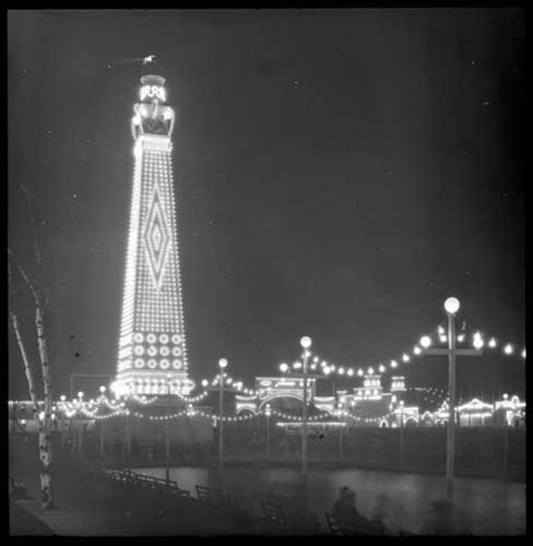 | Illuminated tower and beacon - Scarboro Beach Park 117 years ago - 1907 - The Beaches at 60 Scarborough Beach Boulevard Link to archive record - Map location (From Archives of Ontario) |
| 1908 |  | Spectators watching water chute ride, Scarborough Beach Park 116 years ago - 1908 - The Beaches at 60 Scarborough Beach Boulevard Link to archive record - Map location (From the City of Toronto Archives) |
| 1908 |  | Pond in Glen Stewart estate or park 116 years ago - 1908 - The Beaches Link to archive record - Map location (From the City of Toronto Archives) |
| 1908 |  | At the end of the water chute ride at Scarboro Beach Park 116 years ago - 1908 - The Beaches at 60 Scarborough Beach Boulevard Link to archive record - Map location (From the City of Toronto Archives) |
| 1910 | 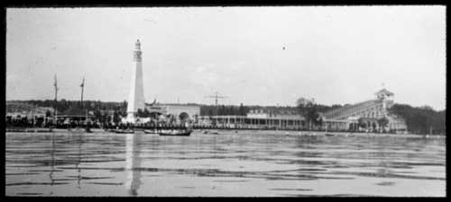 | North shore of Lake Ontario - Scarboro Beach roller coaster and tower 114 years ago - 1910 - The Beaches Link to archive record - Map location (From Archives of Ontario) |
| 1910 |  | Crowd watching lacrosse game, Scarborough Beach Park 114 years ago - Friday, July 1, 1910 - The Beaches at 60 Scarborough Beach Boulevard Max temp: 33.9°C - Min temp: 18.3°C (weather details) Link to archive record - Map location (From the City of Toronto Archives) |
| 1911 |  | Fascinating Women and Charming Gowns snapped at the Woodbine Racetrack 113 years ago - Sunday, June 4, 1911 - The Beaches Max temp: 23.9°C - Min temp: 11.1°C (weather details) Link to archive record - Map location (From the City of Toronto Archives) |
| 1912 |  | Winter storm and ice at Kew Beach 112 years ago - 1912 - The Beaches Link to archive record - Map location (From the City of Toronto Archives) |
| 1912 |  | Glen Stewart Park - water, railing, and horse drawn cart 112 years ago - 1912 - The Beaches Link to archive record - Map location (From the City of Toronto Archives) |
| 1912 | 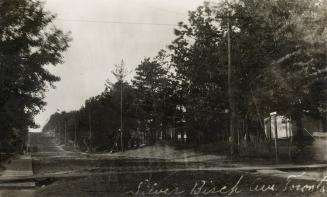 | Silver Birch Ave., looking north from the lakefront 112 years ago - Tuesday, September 24, 1912 - The Beaches Max temp: 15.6°C - Min temp: 14.4°C (weather details) Link to archive record - Map location (From the Toronto Public Library Still not back as of March 2024) |
| 1919 |  | Lake Ontario shoreline west from Munro Park Ave. - Erosion of the lakeshore 105 years ago - Monday, May 12, 1919 - The Beaches Max temp: 13.9°C - Min temp: 5.6°C (weather details) Link to archive record - Map location (From the City of Toronto Archives) |
| 1919 |  | Entrance to the Cascades, Scarborough Beach Park 105 years ago - Thursday, August 28, 1919 - The Beaches at 60 Scarborough Beach Boulevard Max temp: 22.8°C - Min temp: 10.6°C (weather details) Link to archive record - Map location (From the City of Toronto Archives) |
| 1919 |  | Inside the Cascades amusement ride, Scarborough Beach Park 105 years ago - Thursday, August 28, 1919 - The Beaches at 60 Scarborough Beach Boulevard Max temp: 22.8°C - Min temp: 10.6°C (weather details) Link to archive record - Map location (From the City of Toronto Archives) |
| 1920 |  | Dr. Young Monument, Kew Beach, Toronto 104 years ago - 1920 - The Beaches at 46 Lee Ave Link to archive record - Map location (From Archives of Ontario) |
| 1922 |  | A.S. Goss, wife and children, in garden of 53 Neville Park Boulevard 102 years ago - Monday, July 31, 1922 - The Beaches at 53 Neville Park Boulevard Max temp: 23.3°C - Min temp: 16.7°C (weather details) Link to archive record - Map location (From the City of Toronto Archives) |
| 1922 |  | Kingston Rd, looking west, from Victoria Park Ave 102 years ago - Monday, October 16, 1922 - The Beaches Max temp: 18.9°C - Min temp: 7.8°C (weather details) Link to archive record - Map location (From the City of Toronto Archives) |
| 1924 | 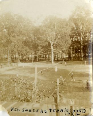 | Kew Gardens grass tennis courts between Waverley Rd. & Lee Ave. 100 years ago - 1924 - The Beaches Link to archive record - Map location (From the Toronto Public Library Still not back as of March 2024) |
| 1926 |  | Bicycle race at Velodrome, Scarborough Beach Park 98 years ago - 1926 - The Beaches at 60 Scarborough Beach Boulevard Link to archive record - Map location (From the City of Toronto Archives) |
| 1929 |  | Kew Beach Park East - wooden groynes to reduce sand erosion along the beach 95 years ago - Tuesday, November 19, 1929 - The Beaches at 2075 Queen Street East Max temp: 3.3°C - Min temp: -0.6°C (weather details) Link to archive record - Map location (From the City of Toronto Archives) |
| 1930 |  | Houses on Kewbeach Avenue - numbers 9, 11, 13 - back on to the water and expropriated for Woodbine Beach Park 94 years ago - Monday, March 10, 1930 - The Beaches at 9 Kewbeach Ave Link to archive record - Map location (From the City of Toronto Archives) |
| 1930 |  | Houses at 15, 17 Kew Beach Avenue 94 years ago - Monday, March 10, 1930 - The Beaches at 15 Kewbeach Ave Link to archive record - Map location (From the City of Toronto Archives) |
| 1930 |  | Houses expropriated for Woodbine Beach park - 19, 21, 23 Kew Beach Avenue 94 years ago - Monday, March 10, 1930 - The Beaches at 19 Kewbeach Ave Link to archive record - Map location (From the City of Toronto Archives) |
| 1930 |  | Homes on Lee Avenue north of Lake Ontario 94 years ago - Saturday, March 22, 1930 - The Beaches at 13 Lee Ave Max temp: 0.0°C - Min temp: -8.3°C (weather details) Link to archive record - Map location (From the City of Toronto Archives) |
| 1930 |  | Leuty Avenue north of the beach with horse drawn wagon 94 years ago - Saturday, March 22, 1930 - The Beaches at 22 Leuty Ave Max temp: 0.0°C - Min temp: -8.3°C (weather details) Link to archive record - Map location (From the City of Toronto Archives) |
| 1931 |  | Colour sketch of a gate for the Kew Beach athletic field (Categorized under: Architectural drawings --- Ornamental gate ) 93 years ago - 1931 - The Beaches Link to archive record - Map location (From the City of Toronto Archives) |
| 1935 |  | Kew Beach Public School - before 1963 new school was built - was 95 Kippendavie Ave. at the time (Categorized under: Schools ) 89 years ago - 1935 - The Beaches at 101 Kippendavie Ave Link to archive record - Map location (From the City of Toronto Archives) |
| 1960 |  | Duke of Connaught Public School - Woodfield Road at Queen Street East (Categorized under: Schools ) 64 years ago - 1960 - The Beaches at 70 Woodfield Road north of Queen Street East Link to archive record - Map location (From the City of Toronto Archives) |
| 1977 |  | Ashbridges Estate - built in 1854 and designed by Joseph Sheard - at Connaught Avenue 47 years ago - Thursday, May 26, 1977 - The Beaches at 1444 Queen Street East at Connaught Avenue Link to archive record - Map location (From the City of Toronto Archives) |