Historic Toronto photos from September 11There are a number of great web sites that provide historic photos from around Toronto. As I was collecting them for an interactive historic map of the city I realized that it was also interesting to find photos that were taken around the current time of the year.If you'd like to see photos from today, you can always load this page without parameters to see the last few days worth of photos. You can also see all the historic photos for a given neighbourhood. A subset of the photos have also been arranged by subject. Tweet |
| 1894 | 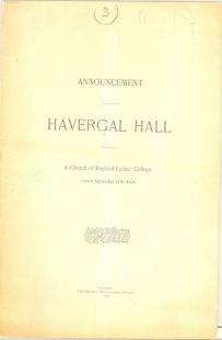 | Havergal Hall Pamphlet, 1894: announcing a new Toronto girls' school at 350 Jarvis Street (Categorized under: Havergal college ) 130 years ago - Tuesday, September 11, 1894 - Garden District at 354 Jarvis Street Link to archive record - Map location |
| 1914 |  | Kids in costumes for the Model Playground - Exhibition Park 110 years ago - Friday, September 11, 1914 - CNE Max temp: 15.0°C - Min temp: 10.0°C (weather details) Link to archive record - Map location (From the City of Toronto Archives) |
| 1914 |  | Model Playground exhibit - Exhibition Park 110 years ago - Friday, September 11, 1914 - CNE Max temp: 15.0°C - Min temp: 10.0°C (weather details) Link to archive record - Map location (From the City of Toronto Archives) |
| 1937 |  | Looking south at the Avenue Road bottleneck from St. Clair Avenue West 87 years ago - Saturday, September 11, 1937 - South Hill at 468 Avenue Road At St Clair Ave West Max temp: 20.6°C - Min temp: 13.3°C (weather details) Link to archive record - Map location (From the City of Toronto Archives) |
| 1951 |  | Mt. Pleasant Road north from Millwood - Bill Jackson Hardware 73 years ago - Tuesday, September 11, 1951 - Davisville Village Max temp: 28.3°C - Min temp: 16.7°C (weather details) Link to archive record - Map location (From the City of Toronto Archives) |
| 1956 | 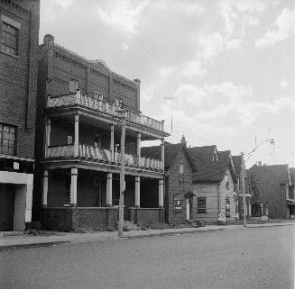 | James Robinson Mavety St. CPR boarding house - nicknamed 'Dog & Pot' - a smallpox epidemic started here 68 years ago - Tuesday, September 11, 1956 - The Junction at 213 Mavety Street (approx.) south of Dundas Street West Max temp: 21.7°C - Min temp: 13.9°C (weather details) Link to archive record - Map location (From the Toronto Public Library Still not back as of March 2024) |