There are a number of great web sites that provide historic photos from around Toronto. As I was collecting them for an
I realized that it was also interesting to find photos that were taken around the current time of the year.
| 1914 |
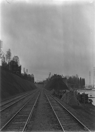 | Site for Wilson Ave. bridge, Sunnyside Railway Cutting
(Categorized under: Wilson Ave pedestrian bridge )
110 years ago - Tuesday, November 3, 1914
- King Street West at 1526 King Street West
Link to archive record
- Map location
(From the Library and Archives Canada) |
| 1924 |
 | New St. Clair bridge construction with old Avoca Avenue bridge still in use, birds eye view from tower looking west
100 years ago - Monday, November 3, 1924
- Moore Park
Max temp: 7.8°C - Min temp: -1.7°C (weather details)
Link to archive record
- Map location
(From the City of Toronto Archives) |
| 1927 |
 | Palace Theatre at Danforth and Pape, north-east corner
(Categorized under: East end theatres )
97 years ago - Thursday, November 3, 1927
- The Danforth
Max temp: 7.2°C - Min temp: 2.2°C (weather details)
Link to archive record
- Map location
(From the City of Toronto Archives) |
| 1932 |
 | Stack foundation - Symes Road Incinerator
92 years ago - Thursday, November 3, 1932
- Harwood at 150 Symes Road at Glen Scarlett Road
Max temp: 4.4°C - Min temp: -2.2°C (weather details)
Link to archive record
- Map location
(From the City of Toronto Archives) |
| 1933 |
 | Lawrence Park Ravine - north of Lympstone Avenue
91 years ago - Friday, November 3, 1933
- Lawrence Park at 3055 Yonge Street
Max temp: 10.0°C - Min temp: 3.9°C (weather details)
Link to archive record
- Map location
(From the City of Toronto Archives) |
| 1933 |
 | Lawrence Park Ravine - north of Lympstone Avenue
91 years ago - Friday, November 3, 1933
- Lawrence Park at 3055 Yonge Street
Max temp: 10.0°C - Min temp: 3.9°C (weather details)
Link to archive record
- Map location
(From the City of Toronto Archives) |
| 1933 |
 | Lawrence Park Ravine - south of Lympstone
91 years ago - Friday, November 3, 1933
- Lawrence Park at 3055 Yonge Street
Max temp: 10.0°C - Min temp: 3.9°C (weather details)
Link to archive record
- Map location
(From the City of Toronto Archives) |
| 1960 |
 | Front Street, north side opposite O'Keefe Centre at Scott Street
64 years ago - Thursday, November 3, 1960
- St. Lawrence at 28 Front Street East (approx.) at Scott Street
Link to archive record
- Map location
(From the City of Toronto Archives) |
| | |  Previous day with photos - next day with photos Previous day with photos - next day with photos 
 Be sure to subscribe to the RSS feed here for regular updates. Be sure to subscribe to the RSS feed here for regular updates.
|