Historic Toronto photos from March 7
There are a number of great web sites that provide historic photos from around Toronto. As I was collecting them for an interactive historic map of the city I realized that it was also interesting to find photos that were taken around the current time of the year.If you'd like to see photos from today, you can always load this page without parameters to see the last few days worth of photos.
You can also see all the historic photos for a given neighbourhood. A subset of the photos have also been arranged by subject.
Tweet| 1927 |  | Browns Hotel - 630 Weston Road South (Categorized under: Hotels ) 97 years ago - Monday, March 7, 1927 - Weston at 630 Weston Road Link to archive record - Map location (From the City of Toronto Archives) |
| 1935 |  | Sketch of side elevation of the Wanless Park fieldhouse (Categorized under: Architectural drawings ) 89 years ago - Thursday, March 7, 1935 - Wanless Park at 250 Wanless Ave Max temp: -2.2°C - Min temp: -6.1°C (weather details) Link to archive record - Map location (From the City of Toronto Archives) |
| 1938 |  | 21 Draper Street being demolished (built 1881) now the 'Cat Promenade' to connect to The Well 86 years ago - Monday, March 7, 1938 - Wellington Place at 19 Draper Street Max temp: 0.6°C - Min temp: -3.9°C (weather details) Link to archive record - Map location (From the City of Toronto Archives) |
| 1938 |  | Draper Park now - back of 21 Draper Street - built in the 19th Century Second Empire-style 86 years ago - Monday, March 7, 1938 - Wellington Place at 19 Draper Street Max temp: 0.6°C - Min temp: -3.9°C (weather details) Link to archive record - Map location (From the City of Toronto Archives) |
| 1940 |  | St. Clair dump on north side, east of Bathurst where subways station is now 84 years ago - Thursday, March 7, 1940 - Forest Hill at 396 St Clair Ave West Max temp: -2.2°C - Min temp: -6.1°C - 0.3cm of snowfall (weather details) Link to archive record - Map location (From the City of Toronto Archives) |
| 1979 |  | St. Michael's Cathedral - view up to window details on the roof (Categorized under: St Michaels Cathedral ) 45 years ago - Wednesday, March 7, 1979 - Garden District at 200 Church Street n.e. corner at Shuter Street Link to archive record - Map location (From the City of Toronto Archives) |
| 1979 |  | Outside view of a rose window in St. Michaels Cathedral (Categorized under: St Michaels Cathedral ) 45 years ago - Wednesday, March 7, 1979 - Garden District at 200 Church Street n.e. corner at Shuter Street Link to archive record - Map location (From the City of Toronto Archives) |
| 1998 | 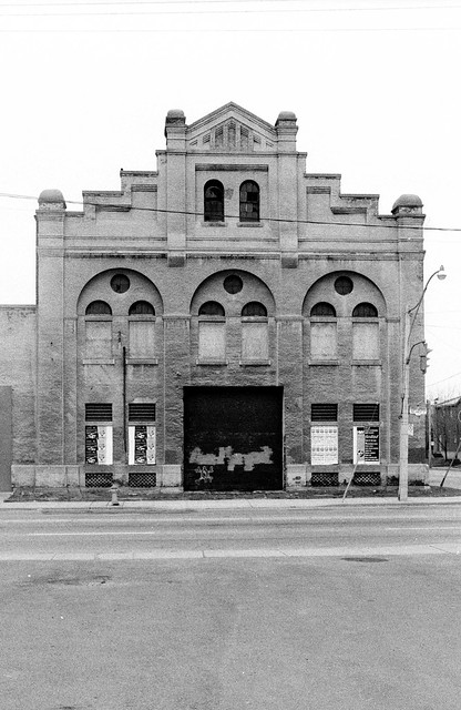 | Consumers' Gas Co, Station A. Built in 1898 51 Parliament St - March 7, 1998 26 years ago - Saturday, March 7, 1998 - Corktown at 51 Parliament Street n.e corner at Front Street East Max temp: 5.4°C - Min temp: -0.2°C (weather details) Link to archive record - Map location (From Collations Flickr stream) |