Historic Toronto photos from April 16
There are a number of great web sites that provide historic photos from around Toronto. As I was collecting them for an interactive historic map of the city I realized that it was also interesting to find photos that were taken around the current time of the year.If you'd like to see photos from today, you can always load this page without parameters to see the last few days worth of photos.
You can also see all the historic photos for a given neighbourhood. A subset of the photos have also been arranged by subject.
Tweet| 1935 |  | King Street West, looking west to Wilson Avenue (Categorized under: Wilson Ave pedestrian bridge ) 89 years ago - Tuesday, April 16, 1935 - King Street West at 1526 King Street West Max temp: 3.9°C - Min temp: -3.9°C - 0.5cm of snowfall (weather details) Link to archive record - Map location (From the City of Toronto Archives) |
| 1957 | 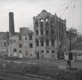 | Reinhardt Brewery Company, after Central Storage Company warehouse fire (was Don Roadway West) 67 years ago - Tuesday, April 16, 1957 - Regent Park at 32 Mark Street south of Dundas Street East Max temp: 9.4°C - Min temp: 2.8°C (weather details) Link to archive record - Map location (From the Toronto Public Library Still not back as of March 2024) |
| 1959 |  | Before Avenue Road widening outside the The Avenue Rd. Church (Categorized under: Avenue road church (at roxborough) ) 65 years ago - Thursday, April 16, 1959 - Summerhill at 243 Avenue Road Max temp: 24.4°C - Min temp: 8.9°C (weather details) Link to archive record - Map location (From the City of Toronto Archives) |