Historic Toronto photos from February 4There are a number of great web sites that provide historic photos from around Toronto. As I was collecting them for an interactive historic map of the city I realized that it was also interesting to find photos that were taken around the current time of the year.If you'd like to see photos from today, you can always load this page without parameters to see the last few days worth of photos. You can also see all the historic photos for a given neighbourhood. A subset of the photos have also been arranged by subject. Tweet |
| 1914 |  | Moore Avenue, Belt Line railway looking southwest (Categorized under: Belt Line trail ) 110 years ago - Wednesday, February 4, 1914 - Moore Park Max temp: 2.8°C - Min temp: -5.6°C (weather details) Link to archive record - Map location (From the City of Toronto Archives) |
| 1956 | 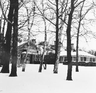 | Toronto Hunt Club on Kingston Road, s. side, between Woodglen Road & Haig Ave 68 years ago - Saturday, February 4, 1956 - Hunt Club at 1355 Kingston Road Max temp: 0.6°C - Min temp: -8.9°C - 11.0cm of snow on the ground (weather details) Link to archive record - Map location (From the Toronto Public Library Still not back as of March 2024) |
| 1984 |  | 247-249 Dundas St E and an awful addition (which remains to this day) 40 years ago - Saturday, February 4, 1984 - Garden District at 247 Dundas Street East Max temp: 2.8°C - Min temp: 0.7°C - 3.2cm of snowfall - 11.0cm of snow on the ground (weather details) Link to archive record - Map location (From Collations Flickr stream) |