Historic Toronto photos from February 20There are a number of great web sites that provide historic photos from around Toronto. As I was collecting them for an interactive historic map of the city I realized that it was also interesting to find photos that were taken around the current time of the year.If you'd like to see photos from today, you can always load this page without parameters to see the last few days worth of photos. You can also see all the historic photos for a given neighbourhood. A subset of the photos have also been arranged by subject. Tweet |
| 1889 | 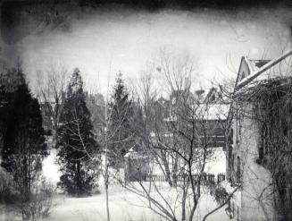 | University College, Deans house and garden, looking w. to the back of houses on St. George 135 years ago - Wednesday, February 20, 1889 - University of Toronto (U of T) Max temp: -7.8°C - Min temp: -14.4°C (weather details) Link to archive record - Map location (From the Toronto Public Library Still not back as of March 2024) |
| 1904 |  | KEW Beach Grocery and Smith - Queen Street west of Lee Avenue 120 years ago - Saturday, February 20, 1904 - The Beaches at 2040 Queen Street East Max temp: -4.4°C - Min temp: -16.1°C (weather details) Link to archive record - Map location (From the City of Toronto Archives) |
| 1932 |  | Southwest corner Hillsdale and Bayview Ave 92 years ago - Saturday, February 20, 1932 - Davisville Village at 1670 Bayview Ave s.w. corner at Hillsdale Avenue West Max temp: -2.2°C - Min temp: -12.8°C (weather details) Link to archive record - Map location (From the City of Toronto Archives) |
| 1935 |  | Suggested colour scheme, Clarke Beach lavatory building for the Parks Dept. (Categorized under: Architectural drawings ) 89 years ago - Wednesday, February 20, 1935 - Cherry Beach Max temp: -2.8°C - Min temp: -8.9°C (weather details) Link to archive record - Map location (From the City of Toronto Archives) |
| 1939 |  | Iron fence outside church on the southeast corner Brock and Atkin Avenue 85 years ago - Monday, February 20, 1939 - Brockton Village Max temp: 3.3°C - Min temp: -8.3°C (weather details) Link to archive record - Map location (From the City of Toronto Archives) |
| 1959 | Avro closes down the CF 105 Avro Arrow project 65 years ago - Friday, February 20, 1959 - Malton at 6301 Silver Dart Drive Link to archive record - Map location (From the Library and Archives Canada) |
|
| 1959 | Avro closes down on the CF 105 fighter jet 65 years ago - Friday, February 20, 1959 - Malton at 6301 Silver Dart Drive Link to archive record - Map location (From the Library and Archives Canada) |
|